Papua New Guinea Volcanoes
-

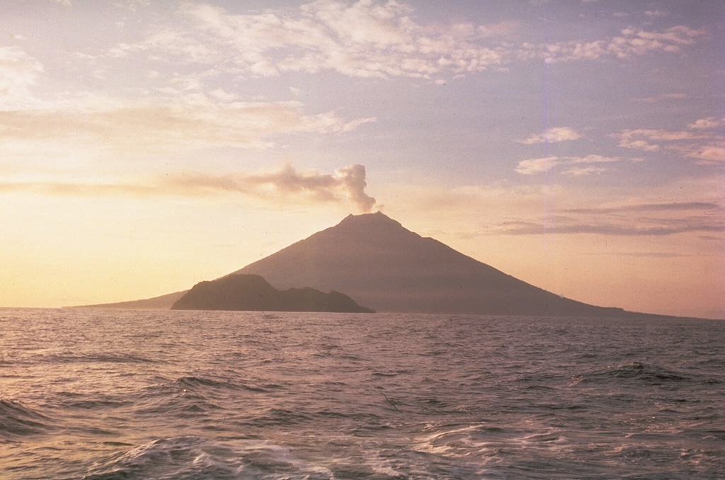
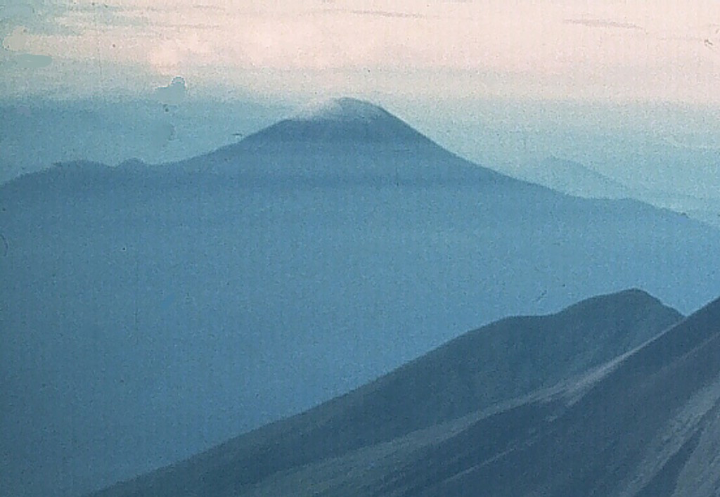
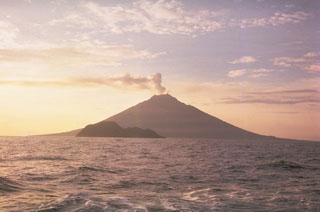
Ulawun
-
Ulawun
-
St. Andrew Strait
-
Lolobau
-
Rabaul
-

Rabaul
-
Boisa
-

Lamington
-

Sulu Range
-
Tavui
-
Blup Blup
-
Bamus
-
Rabaul
-

Ulawun
-

Rabaul
-
Lolobau
-
Bam
-
Tavui
-
Karkar
-
Manam
Papua New Guinea has 44 Holocene volcanoes. Note that as a scientific organization we provide these listings for informational purposes only, with no international legal or policy implications. Volcanoes will be included on this list if they are within the boundaries of a country, on a shared boundary or area, in a remote territory, or within a maritime Exclusive Economic Zone. Bolded volcanoes have erupted within the past 20 years. Suggestions and data updates are always welcome ().
| Volcano Name | Location | Last Eruption | Primary Volcano Type |
|---|---|---|---|
| Ambitle | New Ireland (Papua New Guinea) | 350 BCE | Stratovolcano |
| Bagana | Bougainville (Papua New Guinea) | 2024 CE | Lava cone |
| Balbi | Bougainville (Papua New Guinea) | Unknown - Evidence Credible | Stratovolcano |
| Bam | Northeast of New Guinea | 1960 CE | Stratovolcano |
| Bamus | New Britain (Papua New Guinea) | 1886 CE | Stratovolcano |
| Billy Mitchell | Bougainville (Papua New Guinea) | 1580 CE | Caldera |
| Blup Blup | Northeast of New Guinea | Unknown - Evidence Credible | Stratovolcano |
| Boisa | Northeast of New Guinea | Unknown - Evidence Uncertain | Stratovolcano |
| Bola | New Britain (Papua New Guinea) | Unknown - Evidence Credible | Stratovolcano |
| Central Bismarck Sea | Admiralty Islands | 1972 CE | Fissure vent |
| Dakataua | New Britain (Papua New Guinea) | 1895 CE | Caldera |
| Dawson Strait Group | New Guinea | 1350 CE | Volcanic field |
| Garove | New Britain (Papua New Guinea) | Unknown - Evidence Credible | Stratovolcano |
| Garua Harbour | New Britain (Papua New Guinea) | Unknown - Evidence Uncertain | Volcanic field |
| Goodenough | New Guinea | Unknown - Evidence Credible | Volcanic field |
| Hankow Reef | Northeast of New Guinea | Unknown - Evidence Uncertain | Stratovolcano |
| Hargy | New Britain (Papua New Guinea) | 950 CE | Stratovolcano |
| Hydrographers Range | New Guinea | Unknown - Evidence Credible | Stratovolcano |
| Iamalele | New Guinea | Unknown - Evidence Credible | Lava dome(s) |
| Kadovar | Northeast of New Guinea | 2023 CE | Stratovolcano |
| Karkar | Northeast of New Guinea | 1979 CE | Stratovolcano |
| Krummel-Garbuna-Welcker | New Britain (Papua New Guinea) | 2008 CE | Stratovolcano(es) |
| Lamington | New Guinea | 1956 CE | Stratovolcano |
| Langila | New Britain (Papua New Guinea) | 2024 CE | Complex |
| Lihir | New Ireland (Papua New Guinea) | Unknown - Evidence Credible | Compound |
| Lolo | New Britain (Papua New Guinea) | Unknown - Evidence Uncertain | Stratovolcano |
| Lolobau | New Britain (Papua New Guinea) | 1912 CE | Caldera |
| Loloru | Bougainville (Papua New Guinea) | 1050 BCE | Compound |
| Long Island | Northeast of New Guinea | 1993 CE | Complex |
| Managlase Plateau | New Guinea | Unknown - Evidence Credible | Volcanic field |
| Manam | Northeast of New Guinea | 2024 CE | Stratovolcano |
| Mundua | New Britain (Papua New Guinea) | Unknown - Evidence Credible | Complex |
| Rabaul | New Britain (Papua New Guinea) | 2014 CE | Caldera |
| Ritter Island | Northeast of New Guinea | 2007 CE | Stratovolcano |
| Sakar | Northeast of New Guinea | Unknown - Evidence Uncertain | Stratovolcano |
| Sessagara Hills | New Guinea | 1944 CE | Volcanic field |
| St. Andrew Strait | Admiralty Islands | 1957 CE | Complex |
| Sulu Range | New Britain (Papua New Guinea) | Unknown - Unrest / Holocene | Stratovolcano(es) |
| Takuan Group | Bougainville (Papua New Guinea) | Unknown - Evidence Credible | Compound |
| Tavui | New Britain (Papua New Guinea) | 4946 BCE | Caldera |
| Ulawun | New Britain (Papua New Guinea) | 2023 CE | Stratovolcano |
| Umboi | Northeast of New Guinea | Unknown - Evidence Credible | Complex |
| Victory | New Guinea | 1935 CE | Stratovolcano |
| Witori | New Britain (Papua New Guinea) | 2012 CE | Caldera |
Chronological listing of known Holocene eruptions (confirmed or uncertain) from volcanoes in Papua New Guinea. Bolded eruptions indicate continuing activity.
| Volcano Name | Start Date | Stop Date | Certainty | VEI | Evidence |
|---|---|---|---|---|---|
| Ulawun | 2023 Jul 18 | 2023 Dec 31 | Confirmed | Observations: Reported | |
| Ulawun | 2023 Mar 28 | 2023 Mar 28 | Confirmed | 1 | Observations: Reported |
| Ulawun | 2022 Jun 2 | 2022 Jun 2 | Confirmed | 2 | Observations: Reported |
| Ulawun | 2021 Jul 9 | 2021 Nov 29 | Confirmed | 2 | Observations: Reported |
| Ulawun | 2019 Jun 26 | 2019 Oct 5 | Confirmed | 4 | Observations: Reported |
| Ulawun | 2018 Sep 21 | 2018 Oct 12 | Confirmed | 2 | Observations: Reported |
| Ulawun | 2018 Jun 8 | 2018 Jun 8 | Confirmed | 1 | Observations: Reported |
| Kadovar | 2018 Jan 5 | 2023 May 14 | Confirmed | 2 | Observations: Reported |
| Ulawun | 2017 Jun 11 | 2017 Nov 3 | Confirmed | 1 | Observations: Reported |
| Ulawun | 2016 Oct 11 | 2016 Nov 18 | Confirmed | 1 | Observations: Reported |
| Langila | 2015 Oct 22 (?) | 2024 Apr 19 (continuing) | Confirmed | 2 | Observations: Reported |
| Rabaul | 2014 Jul 7 | 2014 Sep 18 | Confirmed | 4 | Observations: Reported |
| Manam | 2014 Jun 29 | 2024 Mar 9 (continuing) | Confirmed | 4 | Observations: Reported |
| Karkar | [2014 Mar 26] | [2014 Mar 27] | Uncertain | ||
| Langila | [2013 Oct 23] | [2013 Dec 1] | Uncertain | ||
| Ulawun | 2013 Jul 8 | 2013 Dec 21 | Confirmed | 1 | Observations: Reported |
| Karkar | [2013 Jan 29] | [2013 Mar 15] | Uncertain | ||
| Rabaul | 2013 Jan 19 | 2014 Mar 11 | Confirmed | 2 | Observations: Reported |
| Langila | 2012 Dec 1 | 2012 Dec 5 | Confirmed | 1 | Observations: Reported |
| Ulawun | 2012 Nov 6 | 2012 Dec 11 | Confirmed | 1 | Observations: Reported |
| Langila | [2012 Jul 21] | [2012 Jul 21] | Uncertain | ||
| Ulawun | 2012 May 7 | 2012 May 31 | Confirmed | 1 | Observations: Reported |
| Witori | 2012 May 3 | 2012 Jul 11 | Confirmed | 3 | Observations: Reported |
| Karkar | [2012 Feb 1] | [2012 Feb 1] | Uncertain | ||
| Langila | [2011 Jul 28] | [2011 Jul 28] | Uncertain | ||
| Rabaul | 2011 Mar 29 | 2011 Aug 12 | Confirmed | 2 | Observations: Reported |
| Manam | 2010 Aug 10 (?) | 2013 Dec 15 (in or after) | Confirmed | 3 | Observations: Reported |
| Rabaul | 2010 Jul 23 | 2010 Jul 25 | Confirmed | 1 | Observations: Reported |
| Ulawun | 2010 May 26 ± 4 days | 2011 May 27 | Confirmed | 2 | Observations: Reported |
| Karkar | [2010 Feb 25] | [2010 Feb 26] | Uncertain | ||
| Langila | 2009 Sep 16 (in or before) ± 15 days | 2010 Feb 16 (?) ± 15 days | Confirmed | 2 | Observations: Reported |
| Karkar | [2009 May 1 ± 30 days] | [Unknown] | Uncertain | ||
| Krummel-Garbuna-Welcker | 2008 Jul 13 | 2008 Oct 4 | Confirmed | 2 | Observations: Reported |
| Krummel-Garbuna-Welcker | 2008 Mar 11 | 2008 Mar 13 | Confirmed | 1 | Observations: Reported |
| Ulawun | [2007 Dec 25] | [Unknown] | Uncertain | ||
| Witori | 2007 Aug 28 | 2007 Aug 28 | Confirmed | 1 | Observations: Reported |
| Ritter Island | 2007 May 19 | 2007 May 21 (?) | Confirmed | 1 | Observations: Reported |
| Ulawun | 2007 May 1 | 2007 May 1 | Confirmed | 2 | Observations: Reported |
| Ritter Island | 2006 Oct 17 | 2006 Oct 17 (?) | Confirmed | 1 | Observations: Reported |
| Rabaul | 2006 Aug 11 | 2010 Jan 31 | Confirmed | 4 | Observations: Reported |
| Langila | 2006 Aug 9 | 2008 Jul 6 (?) | Confirmed | 2 | Observations: Reported |
| Ulawun | 2006 Mar 1 | 2007 Jan 18 | Confirmed | 2 | Observations: Reported |
| Krummel-Garbuna-Welcker | 2005 Oct 16 | 2005 Nov 17 (in or after) | Confirmed | 2 | Observations: Reported |
| Langila | 2005 Apr 19 (?) | 2006 Mar 31 (?) | Confirmed | 2 | Observations: Reported |
| Ulawun | 2005 Mar 27 (?) | 2005 Aug 9 (?) | Confirmed | 2 | Observations: Reported |
| Rabaul | 2005 Jan 25 | 2006 Feb 17 | Confirmed | 2 | Observations: Reported |
| Langila | 2004 Nov 24 (?) | 2004 Dec 25 (?) | Confirmed | 2 | Observations: Reported |
| Manam | 2004 Oct 24 | 2009 Dec 12 (?) | Confirmed | 4 | Observations: Reported |
| Ulawun | 2004 Apr 12 | 2004 Apr 14 | Confirmed | 2 | Observations: Reported |
| Witori | [2004 Feb 24] | [2004 Feb 24] | Uncertain | ||
| Langila | 2004 Jan 20 (?) | 2004 Jan 27 (?) | Confirmed | 2 | Observations: Reported |
| Manam | 2003 Oct 26 ± 5 days | 2004 Mar 28 | Confirmed | 1 | Observations: Reported |
| Manam | 2003 May 17 | 2003 May 23 | Confirmed | 1 | Observations: Reported |
| Ulawun | 2003 Apr 14 (?) | 2003 Oct 10 | Confirmed | 2 | Observations: Reported |
| Manam | 2002 Oct 31 | Unknown | Confirmed | 2 | Observations: Reported |
| Rabaul | 2002 Oct 6 (?) | 2004 Feb 17 | Confirmed | 2 | Observations: Reported |
| Ulawun | 2002 Aug 22 (?) | 2002 Nov 3 | Confirmed | 2 | Observations: Reported |
| Witori | 2002 Aug 3 | 2003 Mar 26 ± 25 days | Confirmed | 3 | Observations: Reported |
| Ritter Island | [2002 Aug 2] | [2002 Aug 2] | Uncertain | ||
| Langila | 2002 May 25 (?) | 2003 Apr 9 (?) | Confirmed | 2 | Observations: Reported |
| Manam | 2002 Jan 13 | 2002 May 21 | Confirmed | 3 | Observations: Reported |
| Ulawun | 2001 Aug 28 | 2001 Aug 28 | Confirmed | 2 | Observations: Reported |
| Manam | 2001 Jun 14 | 2001 Jun 25 (?) | Confirmed | 2 | Observations: Reported |
| Ulawun | 2001 Jan 16 (?) | 2001 May 3 | Confirmed | 3 | Observations: Reported |
| Ulawun | 2000 Sep 28 | 2000 Nov 1 | Confirmed | 4 | Observations: Reported |
| Manam | 2000 Jun 3 | 2000 Jun 4 | Confirmed | 2 | Observations: Reported |
| Bagana | 2000 Feb 28 (in or before) | 2024 Apr 19 (continuing) | Confirmed | 2 | Observations: Reported |
| Ulawun | 1999 Oct 20 | 1999 Oct 20 | Confirmed | 1 | Observations: Reported |
| Rabaul | 1995 Nov 28 | 2001 Sep 5 ± 4 days | Confirmed | 2 | Observations: Reported |
| Rabaul | 1994 Sep 19 | 1995 Apr 16 | Confirmed | 4 | Observations: Reported |
| Ulawun | 1994 Apr 19 (?) | 1994 Jun 16 ± 15 days | Confirmed | 1 | Observations: Reported |
| Long Island | 1993 Nov 3 (?) | 1993 Nov 25 ± 5 days | Confirmed | 1 | Observations: Reported |
| Ulawun | 1993 Jan 12 | 1993 Jan 31 (?) | Confirmed | 2 | Observations: Reported |
| Ulawun | 1989 Jan 1 | 1989 Dec 16 (?) ± 15 days | Confirmed | 2 | Observations: Reported |
| Ulawun | 1985 Nov 17 | 1985 Nov 22 | Confirmed | 3 | Observations: Reported |
| Ulawun | 1984 Dec 30 | 1985 Jan 27 | Confirmed | 1 | Observations: Reported |
| Ulawun | 1984 Aug 23 | 1984 Sep 11 | Confirmed | 1 | Observations: Reported |
| Ulawun | 1983 Nov 6 | 1984 Mar 13 | Confirmed | 1 | Observations: Reported |
| Ulawun | 1980 Oct 6 | 1980 Oct 7 | Confirmed | 3 | Observations: Reported |
| Karkar | [1980 Jan 7] | [1980 Jan 17] | Uncertain | ||
| Karkar | 1979 Jan 12 (?) | 1979 Aug 9 | Confirmed | 2 | Observations: Reported |
| Ulawun | 1978 May 7 | 1978 May 14 | Confirmed | 3 | Observations: Reported |
| Long Island | 1976 Jan 2 ± 120 days | Unknown | Confirmed | 1 | Observations: Reported |
| Karkar | 1974 Dec 30 (?) | 1975 Jun 26 | Confirmed | 2 | Observations: Reported |
| Ritter Island | 1974 Oct 17 | 1974 Oct 17 | Confirmed | 1 | Observations: Reported |
| Manam | 1974 Mar 4 (?) | 1999 Nov 9 (?) | Confirmed | 3 | Observations: Reported |
| Karkar | 1974 Feb 14 | 1974 Aug 8 | Confirmed | 2 | Observations: Reported |
| Ulawun | 1973 Oct 4 | 1973 Oct 19 | Confirmed | 2 | Observations: Reported |
| Long Island | 1973 Apr 16 ± 15 days | 1974 Feb 28 | Confirmed | 2 | Observations: Reported |
| Langila | 1973 Feb 24 ± 4 days | 2000 Oct 16 (in or after) ± 15 days | Confirmed | 3 | Observations: Reported |
| Ritter Island | 1972 Oct 9 | 1972 Oct 9 | Confirmed | 1 | Observations: Reported |
| Bagana | 1972 Jul 2 ± 182 days | 1995 Jul 2 (in or after) ± 182 days | Confirmed | 2 | Observations: Reported |
| Central Bismarck Sea | 1972 Jan 8 | 1972 Jan 12 | Confirmed | 0 | Observations: Hydrophonic |
| Langila | 1971 Jan 26 ± 5 days | 1972 Jul 5 ± 4 days | Confirmed | 2 | Observations: Reported |
| Bagana | 1970 May 21 ± 15 days | 1971 Aug 16 (in or after) ± 15 days | Confirmed | 2 | Observations: Reported |
| Langila | 1970 May 20 | 1970 Sep 22 | Confirmed | 2 | Observations: Reported |
| Ulawun | 1970 Jan 15 | 1970 Feb 11 | Confirmed | 3 | Observations: Reported |
| Langila | 1969 Sep 29 | 1969 Sep 29 | Confirmed | 2 | Observations: Reported |
| Bagana | 1968 Aug 16 ± 15 days | 1968 Aug 16 ± 15 days | Confirmed | 2 | Observations: Reported |
| Long Island | 1968 Mar 16 | 1968 Jun 12 | Confirmed | 2 | Observations: Reported |
| Ulawun | 1967 Jan 22 | 1967 Dec 28 | Confirmed | 2 | Observations: Reported |
| Langila | 1967 Jan 19 | 1968 Jun 16 ± 15 days | Confirmed | 2 | Observations: Reported |
| Bagana | 1966 Mar 20 | 1967 Nov 30 | Confirmed | 3 | Observations: Reported |
| Manam | 1965 Jul 2 ± 182 days | 1966 Jan 25 (in or after) | Confirmed | 2 | Observations: Reported |
| Langila | 1964 Dec 4 ± 4 days | 1966 Sep 23 ± 3 days | Confirmed | 2 | Observations: Reported |
| Bagana | 1964 Apr 24 | 1965 Jul 2 ± 182 days | Confirmed | 2 | Observations: Reported |
| Manam | 1963 Nov 26 | 1964 Apr 16 ± 15 days | Confirmed | 2 | Observations: Reported |
| Ulawun | 1963 Mar 17 | 1963 May 2 (?) | Confirmed | 2 | Observations: Reported |
| Manam | 1963 Feb 15 ± 14 days | 1963 May 8 (in or after) | Confirmed | 2 | Observations: Reported |
| Karkar | [1962 Jul 2 (?) ± 182 days] | [Unknown] | Uncertain | ||
| Manam | 1962 Apr 16 ± 15 days | Unknown | Confirmed | 2 | Observations: Reported |
| Langila | 1962 Mar 16 ± 15 days | 1963 Aug 11 | Confirmed | 2 | Observations: Reported |
| Bagana | 1962 Feb 15 | 1963 Jul 2 ± 182 days | Confirmed | 2 | Observations: Reported |
| Bagana | 1961 Jul 26 | Unknown | Confirmed | 2 | Observations: Reported |
| Manam | 1961 Jul 16 ± 15 days | 1961 Sep 16 ± 15 days | Confirmed | 2 | Observations: Reported |
| Long Island | [1961 Jul 2 ± 182 days] | [Unknown] | Uncertain | ||
| Langila | 1960 Dec 19 | 1961 Sep 25 ± 5 days | Confirmed | 2 | Observations: Reported |
| Ulawun | 1960 Jul 29 ± 3 days | 1962 Nov 16 ± 15 days | Confirmed | 2 | Observations: Reported |
| Bam | 1960 Apr 28 | 1960 Jul 6 | Confirmed | 2 | Observations: Reported |
| Manam | 1959 Dec 16 ± 15 days | 1960 Dec 16 (in or after) ± 15 days | Confirmed | 2 | Observations: Reported |
| Bagana | 1959 Jul 2 (?) ± 182 days | 1960 May 16 ± 15 days | Confirmed | 2 | Observations: Reported |
| Manam | 1959 Jun 16 ± 15 days | 1959 Jul 16 ± 15 days | Confirmed | 2 | Observations: Reported |
| Bam | 1959 Apr 2 | 1959 Oct 31 | Confirmed | 2 | Observations: Reported |
| Bam | 1958 Sep 5 | 1958 Sep 10 | Confirmed | 2 | Observations: Reported |
| Langila | 1958 Apr 21 | 1958 Jun 4 ± 4 days | Confirmed | 2 | Observations: Reported |
| Bam | 1958 Mar 11 ± 10 days | 1958 Apr 19 (?) | Confirmed | 2 | Observations: Reported |
| Ulawun | 1958 Feb 1 ± 60 days | Unknown | Confirmed | 2 | Observations: Reported |
| Bam | 1957 Oct 26 | 1957 Oct 26 | Confirmed | 1 | Observations: Reported |
| Manam | 1956 Dec 8 | 1958 Aug 16 ± 15 days | Confirmed | 3 | Observations: Reported |
| Bagana | 1956 Jul 2 ± 182 days | Unknown | Confirmed | 2 | Observations: Reported |
| Langila | 1956 Mar 25 | 1956 Mar 31 | Confirmed | 2 | Observations: Reported |
| Long Island | 1955 Jun 5 | 1955 Jun 13 | Confirmed | 3 | Observations: Reported |
| Langila | 1955 Jun 1 | 1955 Jun 16 | Confirmed | 2 | Observations: Reported |
| Langila | 1955 Feb 15 | 1955 Feb 17 | Confirmed | 2 | Observations: Reported |
| Bam | 1954 Aug 3 | 1957 Jan 2 | Confirmed | 2 | Observations: Reported |
| Langila | 1954 May 18 | 1954 Nov 13 | Confirmed | 3 | Observations: Reported |
| Manam | 1954 May 16 ± 15 days | 1954 Jun 16 ± 15 days | Confirmed | 2 | Observations: Reported |
| St. Andrew Strait | 1953 Jun 27 | 1957 Jan 28 | Confirmed | 2 | Observations: Reported |
| Bagana | 1953 Jun 16 ± 15 days | 1953 Sep 16 ± 15 days | Confirmed | 3 | Observations: Reported |
| Long Island | 1953 May 8 | 1954 Jan 7 | Confirmed | 3 | Observations: Reported |
| Manam | 1953 Apr 16 ± 15 days | 1953 Aug 16 ± 15 days | Confirmed | 2 | Observations: Reported |
| Bagana | 1952 Feb 29 | 1952 Oct 16 ± 15 days | Confirmed | 4 | Observations: Reported |
| Ulawun | [1951 Jul 2 ± 182 days] | [Unknown] | Uncertain | ||
| Lamington | 1951 Jan 17 | 1956 Jul 2 ± 182 days | Confirmed | 4 | Observations: Reported |
| Bagana | 1948 Dec 1 ± 30 days | 1951 Dec 1 ± 30 days | Confirmed | 3 | Observations: Reported |
| Bam | 1947 Mar 13 ± 75 days | Unknown | Confirmed | 2 | Observations: Reported |
| Manam | 1946 Dec 1 ± 30 days | 1947 Sep | Confirmed | 3 | Observations: Reported |
| Bagana | 1945 | 1947 | Confirmed | 2 | Observations: Reported |
| Bam | 1944 | Unknown | Confirmed | 2 | Observations: Reported |
| Rabaul | 1943 Nov 24 | 1943 Dec 23 (in or after) | Confirmed | 2 | Observations: Reported |
| Sessagara Hills | 1943 Sep 18 | 1944 Aug 31 | Confirmed | 3 | Observations: Reported |
| Bagana | 1943 Apr 7 (in or before) | Unknown | Confirmed | 1 | Observations: Reported |
| Long Island | 1943 | Unknown | Confirmed | Observations: Reported | |
| Langila | [1942 ± 5 years] | [Unknown] | Uncertain | ||
| Rabaul | 1941 Jun 6 | 1942 Mar 31 ± 30 days | Confirmed | 2 | Observations: Reported |
| Ulawun | 1941 Jan 26 | 1941 Jan 26 | Confirmed | 2 | Observations: Reported |
| Rabaul | 1940 Feb 4 ± 4 days | 1940 May 18 | Confirmed | 1 | Observations: Reported |
| Bagana | 1939 Jan 30 (?) | Unknown | Confirmed | 2 | Observations: Reported |
| Bagana | 1938 May 15 | Unknown | Confirmed | 3 | Observations: Reported |
| Long Island | 1938 | Unknown | Confirmed | Observations: Reported | |
| Bagana | 1937 Sep 7 | Unknown | Confirmed | 3 | Observations: Reported |
| Rabaul | 1937 May 29 | 1937 Jun 2 | Confirmed | 4 | Observations: Reported |
| Ulawun | [1937 May] | [Unknown] | Uncertain | ||
| Manam | 1936 Sep | 1939 | Confirmed | 3 | Observations: Reported |
| Bam | [1936 Jul] | [1939 Apr] | Uncertain | ||
| Witori | 1933 Jul (?) | 1933 Aug (?) | Confirmed | 2 | Observations: Reported |
| Long Island | 1933 | Unknown | Confirmed | Observations: Reported | |
| Manam | 1932 | 1934 | Confirmed | 2 | Observations: Reported |
| St. Andrew Strait | [1931] | [Unknown] | Uncertain | ||
| Ulawun | 1927 Jul | 1927 Sep 17 (in or after) | Confirmed | 2 | Observations: Reported |
| Manam | 1926 Mar | 1928 Mar 1 ± 30 days | Confirmed | 2 | Observations: Reported |
| Manam | 1925 | Unknown | Confirmed | 2 | Observations: Reported |
| Manam | [1924] | [Unknown] | Uncertain | ||
| Bam | 1924 | Unknown | Confirmed | 2 | Observations: Reported |
| Manam | [1923] | [Unknown] | Uncertain | ||
| Manam | 1922 | Unknown | Confirmed | 3 | Observations: Reported |
| Manam | 1920 Dec 5 (?) | 1921 Mar | Confirmed | 2 | Observations: Reported |
| Witori | 1920 ± 2 years | Unknown | Confirmed | 0 | Observations: Reported |
| Manam | 1919 Aug 11 | Unknown | Confirmed | 4 | Observations: Reported |
| Ulawun | 1919 May 28 (?) | Unknown | Confirmed | 2 | Observations: Reported |
| Bam | 1918 Sep 18 | Unknown | Confirmed | Observations: Reported | |
| Ulawun | 1918 Jul 21 (?) | Unknown | Confirmed | 2 | Observations: Reported |
| Manam | 1917 | Unknown | Confirmed | 2 | Observations: Reported |
| Ulawun | 1915 Apr | Unknown | Confirmed | 3 | Observations: Reported |
| Bam | 1913 | Unknown | Confirmed | Observations: Reported | |
| Witori | 1911 | 1918 May (?) | Confirmed | 3 | Observations: Reported |
| Lolobau | 1911 | 1912 | Confirmed | 4 | Observations: Reported |
| Bagana | [1909 Jul] | [Unknown] | Uncertain | ||
| Bam | 1909 Apr 19 | 1909 Sep 13 | Confirmed | 2 | Observations: Reported |
| Manam | 1909 | 1914 (?) | Confirmed | 2 | Observations: Reported |
| Bagana | 1908 Jul 15 | Unknown | Confirmed | 2 | Observations: Reported |
| Bam | 1908 Jul 12 | Unknown | Confirmed | 2 | Observations: Reported |
| Lolobau | [1908] | [Unknown] | Uncertain | ||
| Bam | 1907 Nov | Unknown | Confirmed | 2 | Observations: Reported |
| Manam | [1907] | [Unknown] | Uncertain | ||
| Langila | 1907 | Unknown | Confirmed | 2 | Observations: Reported |
| Manam | 1904 Oct 26 | 1904 Oct 27 | Confirmed | 3 | Observations: Reported |
| Lolobau | 1904 Aug 9 | 1905 Oct 18 (in or after) | Confirmed | 4 | Observations: Reported |
| Manam | 1904 Apr 30 ± 30 days | Unknown | Confirmed | Observations: Reported | |
| Manam | [1901] | [1902] | Uncertain | ||
| Langila | 1900 | Unknown | Confirmed | 2 | Observations: Reported |
| Bagana | 1899 | Unknown | Confirmed | Observations: Reported | |
| Manam | 1899 ± 1 years | Unknown | Confirmed | 2 | Observations: Reported |
| Ulawun | 1898 | Unknown | Confirmed | 3 | Observations: Reported |
| Bagana | 1897 May 16 (?) | Unknown | Confirmed | 2 | Observations: Reported |
| Bam | [1897] | [1898] | Uncertain | ||
| Karkar | 1895 Jun 17 | 1895 Aug | Confirmed | 2 | Observations: Reported |
| Dakataua | 1895 ± 5 years | Unknown | Confirmed | 2 | Correlation: Anthropology |
| Bagana | 1894 | 1895 | Confirmed | 2 | Observations: Reported |
| Victory | 1890 (?) | 1935 ± 5 years | Confirmed | 2 | Observations: Reported |
| Langila | 1890 | Unknown | Confirmed | 0 | Observations: Reported |
| Ritter Island | 1888 Mar 13 | 1888 Mar 13 | Confirmed | 2 | Observations: Reported |
| Bam | [1888] | [Unknown] | Uncertain | ||
| Manam | 1887 Jun | 1895 | Confirmed | 2 | Observations: Reported |
| Ritter Island | 1887 Feb 2 | 1887 Feb 5 | Confirmed | 2 | Unknown |
| Bamus | 1886 ± 8 years | Unknown | Confirmed | 3 | Observations: Reported |
| Bam | [1885 May 20] | [Unknown] | Uncertain | ||
| Manam | 1885 May | Unknown | Confirmed | Observations: Reported | |
| Ritter Island | [1885 Jan 13 (?)] | [Unknown] | Uncertain | ||
| Karkar | 1885 | Unknown | Confirmed | 2 | Observations: Reported |
| Langila | 1884 | Unknown | Confirmed | 2 | Observations: Reported |
| Manam | [1884] | [Unknown] | Uncertain | ||
| Bagana | 1883 Dec 31 ± 30 days | Unknown | Confirmed | 3 | Observations: Reported |
| St. Andrew Strait | 1883 Mar 28 | Unknown | Confirmed | 2 | Observations: Reported |
| Bam | [1883 Mar] | [Unknown] | Uncertain | ||
| Ritter Island | [1878 Dec 31 ± 30 days] | [Unknown] | Uncertain | ||
| Rabaul | 1878 Jan 30 (?) | 1878 Feb 26 ± 2 days | Confirmed | 3 | Observations: Reported |
| Langila | 1878 | Unknown | Confirmed | 2 | Observations: Reported |
| Ulawun | 1878 | Unknown | Confirmed | 2 | Observations: Reported |
| Bam | 1877 Nov 13 | Unknown | Confirmed | 3 | Observations: Reported |
| Manam | 1877 Oct 29 | 1877 Nov 13 (in or after) | Confirmed | 2 | Observations: Reported |
| Bam | 1874 May 20 | Unknown | Confirmed | 2 | Observations: Reported |
| Bam | 1872 ± 4 years | Unknown | Confirmed | 3 | Observations: Reported |
| Bagana | 1865 ± 3 years | 1883 | Confirmed | 2 | Observations: Reported |
| Rabaul | 1850 (?) | Unknown | Confirmed | 2 | Observations: Reported |
| Ritter Island | [1848 Apr 13] | [1848 Jul 10 (?)] | Uncertain | ||
| Bagana | 1842 Mar 15 | Unknown | Confirmed | 1 | Observations: Reported |
| Karkar | [1830] | [Unknown] | Uncertain | ||
| Manam | 1830 | Unknown | Confirmed | 2 | Observations: Reported |
| Balbi | [1825 ± 25 years] | [Unknown] | Uncertain | ||
| Victory | [1810 ± 10 years] | [Unknown] | Uncertain | ||
| Witori | 1800 (?) | Unknown | Confirmed | 4 | Correlation: Tephrochronology |
| Ritter Island | 1793 Jun 29 | Unknown | Confirmed | 2 | Observations: Reported |
| Rabaul | 1791 May 22 | Unknown | Confirmed | 2 | Observations: Reported |
| Rabaul | 1767 Sep 10 | Unknown | Confirmed | 2 | Observations: Reported |
| Witori | 1730 ± 25 years | Unknown | Confirmed | Correlation: Tephrochronology | |
| Ritter Island | 1700 Apr 3 (in or before) | 1700 Apr 6 (in or after) | Confirmed | 3 | Observations: Reported |
| Manam | 1700 Apr 2 | Unknown | Confirmed | Observations: Reported | |
| Kadovar | [1700 Apr] | [Unknown] | Uncertain | ||
| Ulawun | 1700 Mar 11 | Unknown | Confirmed | 2 | Observations: Reported |
| Long Island | 1660 ± 20 years | Unknown | Confirmed | 6 | Isotopic: 14C (uncalibrated) |
| Bamus | 1650 ± 50 years | Unknown | Confirmed | Isotopic: 14C (uncalibrated) | |
| Manam | 1643 Apr 21 | Unknown | Confirmed | 2 | Observations: Reported |
| Karkar | 1643 Apr 20 | Unknown | Confirmed | 3 | Observations: Reported |
| Manam | 1616 Jul 6 | Unknown | Confirmed | 2 | Observations: Reported |
| Billy Mitchell | 1580 ± 19 years | Unknown | Confirmed | 6 | Isotopic: 14C (uncalibrated) |
| Witori | 1550 (?) | Unknown | Confirmed | 4 | Correlation: Tephrochronology |
| Witori | 1450 (?) | Unknown | Confirmed | Correlation: Tephrochronology | |
| Rabaul | 1450 ± 150 years | Unknown | Confirmed | Correlation: Tephrochronology | |
| Dawson Strait Group | 1350 (?) | Unknown | Confirmed | Chem/Bio: Hydration Rind | |
| Lolobau | 1100 ± 30 years | Unknown | Confirmed | 4 | Isotopic: 14C (uncalibrated) |
| Karkar | 1070 ± 200 years | Unknown | Confirmed | Isotopic: 14C (uncalibrated) | |
| Witori | 1050 ± 100 years | Unknown | Confirmed | Correlation: Tephrochronology | |
| Billy Mitchell | 1032 ± 23 years | Unknown | Confirmed | 5 | Isotopic: 14C (uncalibrated) |
| Witori | 0950 (?) | Unknown | Confirmed | Correlation: Tephrochronology | |
| Hargy | 0950 (?) | Unknown | Confirmed | Isotopic: 14C (uncalibrated) | |
| Dakataua | 0800 ± 60 years | Unknown | Confirmed | Isotopic: 14C (uncalibrated) | |
| Karkar | 0730 (?) | Unknown | Confirmed | 4 | Isotopic: 14C (uncalibrated) |
| Witori | 0710 ± 75 years | Unknown | Confirmed | 6 | Isotopic: 14C (uncalibrated) |
| Witori | 0690 ± 90 years | Unknown | Confirmed | 5 | Isotopic: 14C (calibrated) |
| Rabaul | 0683 ± 2 years | Unknown | Confirmed | 6 | Isotopic: 14C (calibrated) |
| Dakataua | 0653 ± 18 years | Unknown | Confirmed | 6 | Isotopic: 14C (uncalibrated) |
| Karkar | 0520 ± 100 years | Unknown | Confirmed | 4 | Isotopic: 14C (uncalibrated) |
| St. Andrew Strait | 0350 (?) | Unknown | Confirmed | Isotopic: 14C (uncalibrated) | |
| Witori | 0310 ± 100 years | Unknown | Confirmed | 5 | Isotopic: 14C (calibrated) |
| Krummel-Garbuna-Welcker | 0150 (?) | Unknown | Confirmed | Isotopic: 14C (uncalibrated) | |
| St. Andrew Strait | 0240 BCE ± 100 years | Unknown | Confirmed | Isotopic: 14C (uncalibrated) | |
| Bamus | 0270 BCE ± 50 years | Unknown | Confirmed | Isotopic: 14C (uncalibrated) | |
| Bamus | 0350 BCE ± 75 years | Unknown | Confirmed | Isotopic: 14C (uncalibrated) | |
| Ambitle | 0350 BCE ± 100 years | Unknown | Confirmed | Isotopic: 14C (uncalibrated) | |
| Witori | 0640 BCE ± 300 years | Unknown | Confirmed | Isotopic: 14C (uncalibrated) | |
| Karkar | 0870 BCE ± 75 years | Unknown | Confirmed | Isotopic: 14C (uncalibrated) | |
| Loloru | 1050 BCE (?) | Unknown | Confirmed | Isotopic: 14C (uncalibrated) | |
| Loloru | 1260 BCE ± 300 years | Unknown | Confirmed | Isotopic: 14C (uncalibrated) | |
| Witori | 1370 BCE ± 160 years | Unknown | Confirmed | 6 | Isotopic: 14C (calibrated) |
| Long Island | 2040 BCE ± 110 years | Unknown | Confirmed | 6 | Isotopic: 14C (uncalibrated) |
| Loloru | 2150 BCE (?) | Unknown | Confirmed | Isotopic: 14C (uncalibrated) | |
| Loloru | 3150 BCE (?) | Unknown | Confirmed | Isotopic: 14C (uncalibrated) | |
| Witori | 4000 BCE ± 210 years | Unknown | Confirmed | 6 | Isotopic: 14C (calibrated) |
| Loloru | 4150 BCE (?) | Unknown | Confirmed | Isotopic: 14C (uncalibrated) | |
| Lamington | 4850 BCE ± 300 years | Unknown | Confirmed | Isotopic: 14C (uncalibrated) | |
| Tavui | 4946 BCE ± 40 years | Unknown | Confirmed | 5 | Isotopic: 14C (calibrated) |
| Hargy | 5050 BCE (?) | Unknown | Confirmed | Isotopic: 14C (uncalibrated) | |
| Lamington | 5980 BCE ± 300 years | Unknown | Confirmed | Isotopic: 14C (uncalibrated) | |
| Loloru | 6950 BCE (?) | Unknown | Confirmed | Isotopic: 14C (uncalibrated) | |
| Karkar | 7140 BCE ± 150 years | Unknown | Confirmed | 4 | Isotopic: 14C (uncalibrated) |
| Witori | 7510 BCE ± 150 years | Unknown | Confirmed | Isotopic: 14C (uncalibrated) |
Papua New Guinea has 39 Pleistocene volcanoes. Note that as a scientific organization we provide these listings for informational purposes only, with no international legal or policy implications. Volcanoes will be included on this list if they are within the boundaries of a country, on a shared boundary or area, in a remote territory, or within a maritime Exclusive Economic Zone. Suggestions and data updates are always welcome ().
| Volcano Name | Location | Primary Volcano Type |
|---|---|---|
| Aird Hills | New Guinea and D'Entrecasteaux Islands | Lava dome(s) |
| Bagabag | Northeast of New Guinea | Stratovolcano |
| Bakanovi | Bougainville and Solomon Islands | Stratovolcano |
| Baluan | Admiralty Islands | Stratovolcano |
| Bangum | New Britain | Stratovolcano |
| Biwau Hills | New Guinea and D'Entrecasteaux Islands | Pyroclastic cone(s) |
| Bosavi | New Guinea and D'Entrecasteaux Islands | Stratovolcano |
| Crater Mountain | New Guinea and D'Entrecasteaux Islands | Stratovolcano |
| Crown Island | Northeast of New Guinea | Stratovolcano |
| Darai Hills | New Guinea and D'Entrecasteaux Islands | Volcanic field |
| Doma Peaks | New Guinea and D'Entrecasteaux Islands | Stratovolcano |
| Duau | New Guinea and D'Entrecasteaux Islands | Stratovolcano |
| Emperor Range | Bougainville and Solomon Islands | Caldera(s) |
| Favenc | New Guinea and D'Entrecasteaux Islands | Stratovolcano |
| Giluwe | New Guinea and D'Entrecasteaux Islands | Shield |
| Hagen | New Guinea and D'Entrecasteaux Islands | Stratovolcano(es) |
| Ialibu | New Guinea and D'Entrecasteaux Islands | Stratovolcano |
| Karimui | New Guinea and D'Entrecasteaux Islands | Stratovolcano |
| Kerewa | New Guinea and D'Entrecasteaux Islands | Stratovolcano |
| Koil | Northeast of New Guinea | Stratovolcano |
| Likuruanga | New Britain | Stratovolcano |
| Lotomgan Group | New Britain | Pyroclastic cone(s) |
| Murray | New Guinea and D'Entrecasteaux Islands | Stratovolcano |
| Narage | New Britain | Stratovolcano |
| Numa Numa | Bougainville and Solomon Islands | Stratovolcano |
| Oto Group | New Britain | Stratovolcano(es) |
| Sisa | New Guinea and D'Entrecasteaux Islands | Stratovolcano |
| Suaru | New Guinea and D'Entrecasteaux Islands | Stratovolcano |
| Sugarloaf | New Guinea and D'Entrecasteaux Islands | Volcanic field |
| Tabar | New Ireland (Papua New Guinea) | Stratovolcano |
| Tanga | New Ireland (Papua New Guinea) | Stratovolcano |
| Tangi | New Britain | Stratovolcano |
| Tolokiwa | Northeast of New Guinea | Stratovolcano |
| Tore | Bougainville (Papua New Guinea) | Lava cone |
| Trafalgar | New Guinea and D'Entrecasteaux Islands | Stratovolcano |
| Unea | New Britain | Caldera |
| Viai | Northeast of New Guinea | Stratovolcano |
| Vokeo | Northeast of New Guinea | Stratovolcano |
| Yelia | New Guinea and D'Entrecasteaux Islands | Stratovolcano |
There are 136 photos available for volcanoes in Papua New Guinea.
 Bagana volcano is seen here on 7 October 1964 from the S with the 1964 lava flow descending the western flank to the left. About halfway down the flank the flow divides into four lobes, two of which flow to the W and the other two towards the camera to the S. The 1964 eruption began with explosive activity on 24 April. Lava extrusion soon began and continued into 1965.
Photo by C.D. Branch, 1964 (courtesy of Ben Talai, Rabaul Volcano Observatory).
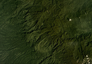
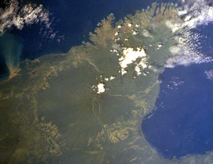
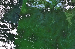 The broad depression above the center of this composite NASA Landsat image of Papua New Guinea (with north to the top) is Crater Mountain. Although this arcuate chain of peaks 3000 m or more in height is extensively eroded, steep-sided valleys to the north and east are floored by lava flows and other young volcanic features. The Purari River cuts across the bottom of the image, and the smaller Pio River parallels it to the north, south of Crater Mountain.
 NASA Landsat 7 image (worldwind.arc.nasa.gov)
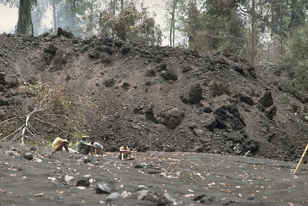
 The vehicle to the right was suspended 3 m above the ground between the tops of two broken trees by the devastating pyroclastic surges of the 21 January 1951 eruption of Mount Lamington. The vehicle was located in the village of Higaturu, 10 km N of the volcano. Velocities of the pyroclastic surges were estimated to be in excess of 120 km per hour. The high-temperature surges destroyed the village, removing houses from their foundations and demolishing a steel-framed hospital building.
Photo by Tony Taylor, 1951 (Australia Bureau of Mineral Resources).
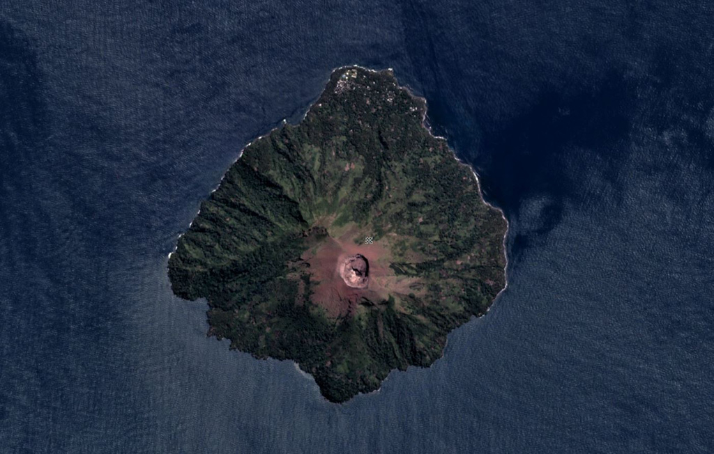
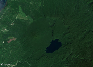
 The roughly 3-km-wide Bam is an island volcano north of the main island of Papua New Guinea. The 300-m-wide, 180-m-deep summit crater is near the center of this May 2018 Planet Labs satellite image monthly mosaic (N is at the top). A NE-trending landslide scarp extends across the edifice from the SW coast.
Satellite image courtesy of Planet Labs Inc., 2018 (https://www.planet.com/).
 An ash plume rises above the summit of Karkar volcano in 1979. There are two nested summit calderas at the summit of the forested volcano resulting in a broad, low profile. The 5.5-km-wide outer caldera was formed during one or more eruptions, the last of which occurred 9,000 years ago. The 3.2-km-wide inner caldera was formed sometime between 1,500 and 800 years ago. Most historical eruptions, like this one in 1979, have originated from Bagiai cone within the 300-m-deep inner caldera.
Photo by Wally Johnson, 1979 (Australia Bureau of Mineral Resources).
 Tavurvur, seen here from the SW on a boat in Matupit Harbor, is one of several post-caldera cones constructed along the NE margin of Rabaul caldera. The cone has an irregular crater rim with a low point on the SW side; its summit and flanks have several overlapping craters. Tavurvur has been the most active of Rabaul's volcanoes, with recorded eruptions since the 18th century. Tavurvur erupted simultaneously with Vulcan on the SW side of the caldera in 1937 and again in 1994.
Photo by Wally Johnson, 1970 (Australia Bureau of Mineral Resources).
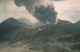
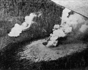
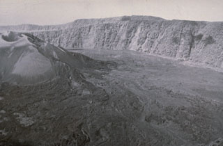 A dominantly effusive eruption with Strombolian activity took place from the Bagiai cone (upper left) in the central caldera during February to August 1974. Lava flows were produced throughout the eruption, except for a 25-day period in July, and covered much of the inner caldera floor. This view from the S caldera rim on 13 September 1974 shows lava flows that were erupted during a period of increased lava effusion on 22 July to 8 August, from a new vent on the SE side of Bagiai.
Photo courtesy of William Melson, 1974 (Smithsonian Institution).
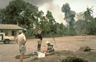
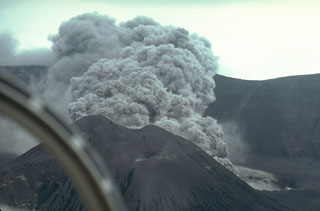 An ash plume rises above a new vent behind Bagiai cone on the floor of Karkar's summit caldera on 17 April 1979. Phreatic eruptions had begun during the night of 12-13 January after six months of increasing seismicity and incandescence. Major phreatic explosions from the new vent on 8 March devastated the caldera rim area, killing two volcanologists who were monitoring the eruption. A new crater formed and intermittent moderate-to-strong explosive activity continued until 9 August.
Photo by William Melson, 1979 (Smithsonian Institution)
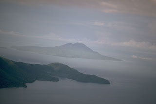
 Rabaul caldera is seen here in 1984 beyond the sulfur-coated walls of Tavurvur crater, located on a post-caldera cone on the NE side of the caldera. Matupit Island lies across Greet Harbor, and the flat-topped Vulcan cone appears on the opposite side of the caldera below the low western caldera rim.
Photo by Dan Dzurisin, 1984 (U.S. Geological Survey).
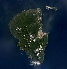
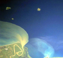 Kadovar is the small circular island at the upper left just above the prominent sediment plume from the Sepik River (lower left) on the mainland of Papua New Guinea. The 2-km-wide island of Kadovar is the emergent summit of a Holocene-age stratovolcano that lacks fringing or offshore reefs. No certain historical eruptions are known, with the latest activity consisting of a period of elevated thermal activity in 1976. Kadovar is part of the Schouten Islands, along with Blup Blup (top left) and Bam (top right).
NASA Space Shuttle image STS106-719-49, 2000 (http://eol.jsc.nasa.gov/).
 The small, 1.4 x 1.7 Boisa Island is seen here in the foreground from the west with steaming Manam volcano in the distance. Boisa consists of a cone with a summit crater open to the N, and a rim extending to the E coast. The crater of the topographically indistinct stratovolcano is filled by two steep-sided lava domes, the largest of which (left) forms the high point of the island.
 Photo by Tony Taylor, 1963 (courtesy of Wally Johnson, Australia Bureau of Mineral Resources).
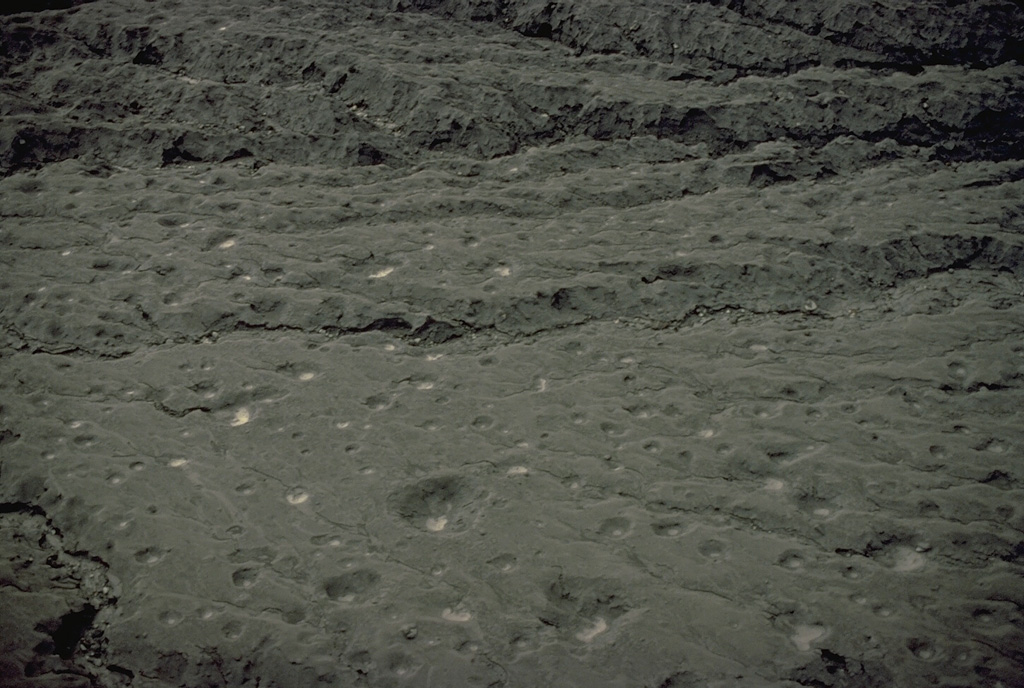
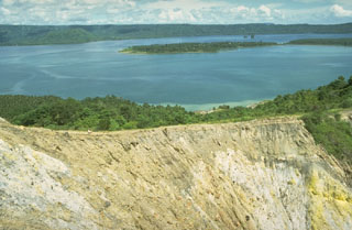
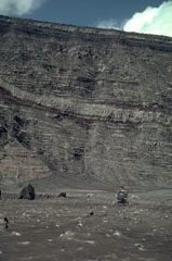 A helicopter on the floor of the inner caldera of Karkar volcano with the 300-m-high caldera wall behind it. The wall was stripped of vegetation by a powerful phreatic explosion on 8 March, revealing the stratigraphy of lighter-colored lava flows and darker pyroclastic deposits that form the edifice. This location is covered by ash and blocks from the March 8 explosion that occurred one month earlier.
Photo by William Melson, 1979 (Smithsonian Institution)
 Langila, one of the most active volcanoes of New Britain, consists of a group of four small overlapping cones on the lower eastern flank of the extinct Talawe volcano. Plumes are shown here on 4 September from Craters 2 (left) and 3 (right) during a 1970 eruption. Frequent mild-to-moderate explosive eruptions, sometimes accompanied by lava flows, have been recorded since the 19th century from the three active craters at the summit.
Photo by Wally Johnson, 1970 (Australia Bureau of Mineral Resources).
 Lava flow morphologies are visible on the eroded, vegetated, flanks of Tore in NW Bougainville Island, Papua New Guinea, in this December 2019 Planet Labs satellite image monthly mosaic (N is at the top; this image is approximately 22 km across). The NW flank of Balbi volcano is in the lower right of this image.
Satellite image courtesy of Planet Labs Inc., 2019 (https://www.planet.com/).
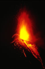 Strombolian eruptions the night of 20 November 1985 ejected incandescent bombs that fell back around the crater and tumbled down the upper flanks. Vigorous Strombolian eruptions resulted in the accumulation of large amounts of unstable material on the upper flanks that produced incandescent avalanches reaching out to 5 km from the crater. This photo was taken three days after the start of the week-long eruption. Lava flows also effused from the summit crater and traveled down the NW flank.
Photo by Wally Johnson, 1985 (Australia Bureau of Mineral Resources).
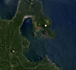 The 8 x 14 km Rabaul caldera is in the center of this September 2018 Planet Labs satellite image monthly mosaic (N is at the top), with several cones that have formed along the perimeter. Tavurvur is the unvegetated cone on the peninsula to the E, then to the NW of that is the crater of Palangiagia. The cone in the middle of the coastline within the harbor is Vulcan. The eroded cone to the north is Tovanumbatir.
Satellite image courtesy of Planet Labs Inc., 2018 (https://www.planet.com/).
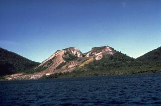
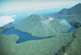
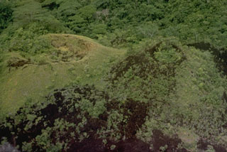
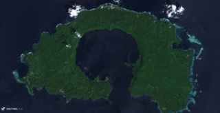
 Lolobau Island lies just off the northern coast of New Britain, west of Cape Deschamp. Lolobau was constructed on the western rim of a 6-km-wide caldera. Eruptive activity from vents on the flank was observed in the early 20th century.
Photo by Robert Citron, 1970 (Smithsonian Institution; courtesy of William Melson)
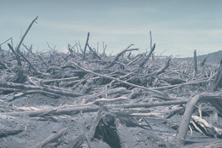 A strong lateral explosion on 8 March 1979 from a vent on the floor of Karkar's inner caldera destroyed vegetation on the southern caldera rim. Trees such as these near the outer margin of the devastated area were snapped off at ground level and were oriented towards the SSE. Foliage was stripped from the trees, branches were torn off, and tree trunks had a sand-blasted appearance.
Photo by William Melson, 1979 (Smithsonian Institution)
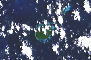
 The roughly 3.5-km-wide Blup Blup is north of the main Papua New Guinea island. The summit crater near the center of the island is visible in this August 2019 Planet Labs satellite image monthly mosaic (N is at the top). A small flank cone is on the SW coast and a submarine debris avalanche deposit is to the NE.
Satellite image courtesy of Planet Labs Inc., 2019 (https://www.planet.com/).
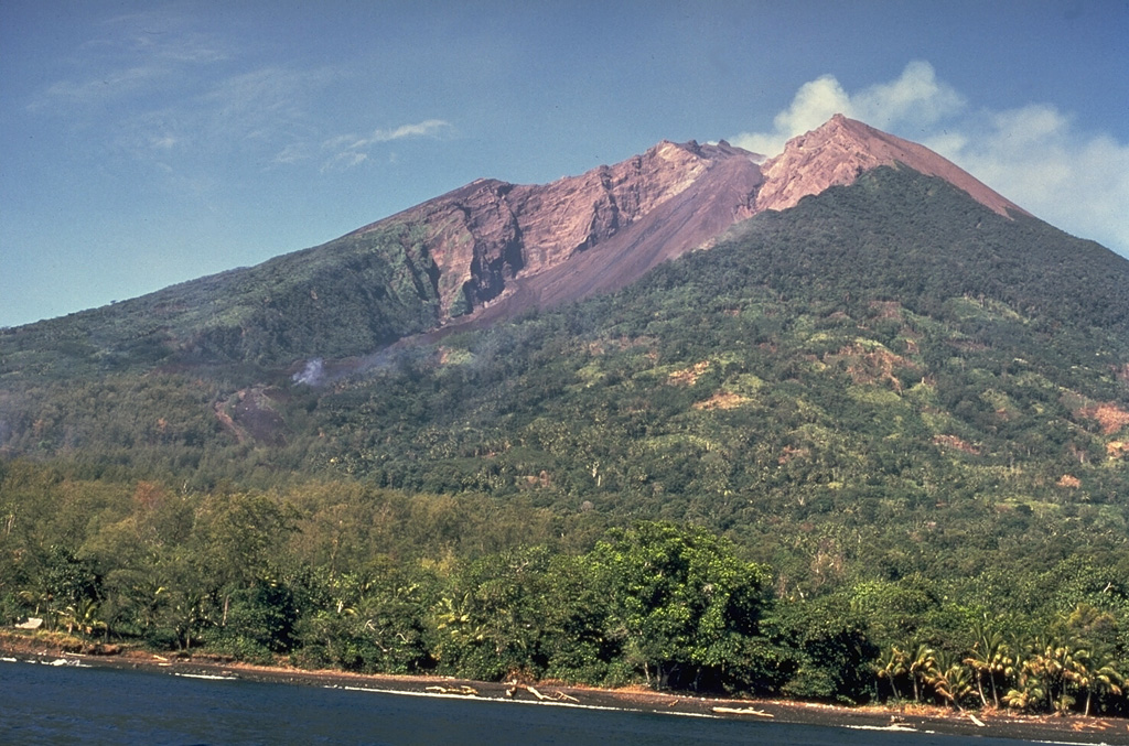
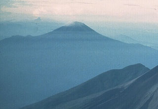 Bamus is seen here from the NE beyond the upper slopes of Ulawun. These two volcanoes are the highest in the 1,000-km-long Bismarck volcanic arc. Bamus is covered by rainforest and contains a summit crater filled with a lava dome. A smaller cone is located on the S flank, and a prominent 1.5-km-wide crater with two small adjacent cones is situated halfway up the SE flank.
Photo by Wally Johnson (Australia Bureau of Mineral Resources).
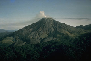
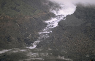
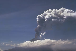 An explosive eruption from Ulawun began on 15 January 1970. On 22 January pyroclastic flows were produced, followed by periodic lava emission that produced a flow reaching 5 km SW of the crater. This photo shows an ash plume rising above the summit on 23 January.
Photo by Wally Johnson, 1970 (Australia Bureau of Mineral Resources).
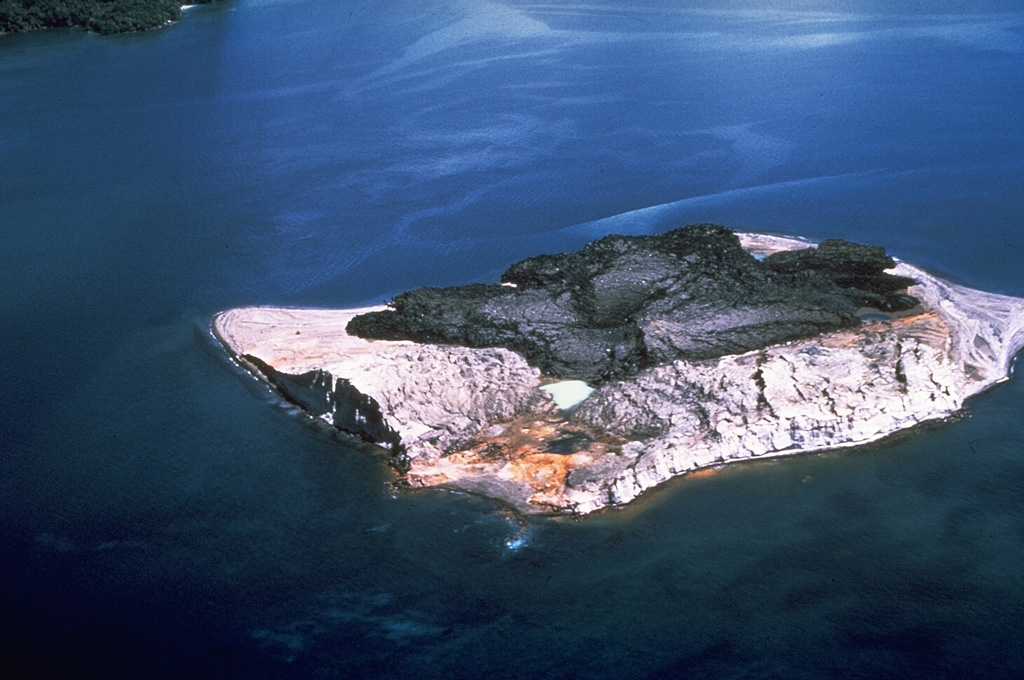
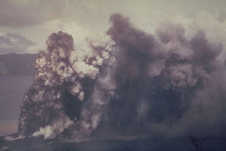
 Phreatic explosions from Motmot Island in Lake Wisdom, on Long Island, during a 1953-54 eruption. The Surtseyan explosion produced a jet of steam and ash seen rising above the lake, and a base surge traveling radially away from the vent across the surface. The western wall of the 10 x 12.5 km Long Island caldera is 200-300 m high in the distance. Twentieth century eruptions at Long Island have originated from vents at or near Motmot Island.
Photo by John Best (courtesy of Wally Johnson, Australia Bureau of Mineral Resources).
 The Dawson Strait Group encompasses a group of cones across several islands including Fergusson (upper left), Normanby (lower left), and Sanaroa (upper right) Islands in Papua New Guinea, seen in this 18 October 2019 Sentinel-2 Satellite image (N is at the top). Dobu Island to the left of Normanby has a roughly 1.5 km wide crater visible here.
Satellite image courtesy of Copernicus Sentinel Data, 2019.
 Crater Mountain is located in the Eastern Highlands Province of Papua New Guinea, seen here in this December 2019 Planet Labs satellite image mosaic (N is at the top). The field is an arcuate chain of eroded peaks containing two craters over 1 km wide and around 30 smaller identified vents.
Satellite image courtesy of Planet Labs Inc., 2019 (https://www.planet.com/).
 The forested volcanic massif at the center of the image is Mount Victory, which occupies the lower part of a peninsula SW of Cape Nelson (upper right). To the NE it abuts the deeply dissected Pleistocene Mount Trafalgar volcano, its summit draped by the larger cloud banks. The summit crater of Mount Victory contains a breached crater and several lava domes. The only confirmed historical activity of Mount Victory was a long-term late-19th to early 20th-century eruption that produced pyroclastic flows that reached the coast.
NASA Space Shuttle image STS093-710-19, 1999 (http://eol.jsc.nasa.gov/).
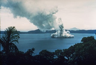
 An ash plume rises above Motmot Island within the Lake Wisdom caldera of Long Island in 1953. Explosions that ejected ash and lapilli began on 8 May. Intermittent explosive activity continued until 7 January 1954.
 Photo by John Best, 1953 (courtesy of Wally Johnson, Australia Bureau of Mineral Resources).
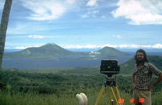 A volcanologist from the Rabaul Volcano Observatory beside an instrument used to make electronic distance measurements (EDM) across Rabaul caldera. Repeated precise measurements of the distance to stations on opposite sides of the caldera are used for monitoring the slow decade-long deformation that preceded a major eruption in 1994. Two pre-caldera peaks, Mount Kombiu (left) and Mount Turanguna (right) are located near the NE caldera rim.
Photo by Norm Banks, 1983 (U.S. Geological Survey).
 Balbi volcano forms the highest point on Bougainville Island and is part of a large number of coalesced cones and lava domes. Five well-preserved craters occupy a NW-SE-trending ridge N of the summit, which also has a crater. Crater C, containing a small lake, is seen here from the E. A plume from a fumarole field on the W flank of 600-m-wide Crater B is visible to the left. The latest eruption may have been as recent as the mid-19th century.
Photo by Wally Johnson, 1987 (Australia Bureau of Mineral Resources).
 The summit of Loloru on SE Bougainville Island has two nested calderas and forested lava dome within the younger one. Loloru is constructed within the 10 x 15 km Pleistocene Laluai caldera; part of the rim of this outer caldera is seen at the lower right. Pyroclastic flow deposits from the volcano cover much of the southern part of the island. The most recent of several major Holocene explosive eruptions took place about 3,000 years ago.
Photo by Wally Johnson, 1988 (Australia Bureau of Mineral Resources).
 A white plume rises above a lava flow descending a channel on the NW flank of Ulawun volcano in February 1970. A pyroclastic flow descended the channel on 22 January to produce the deposits in the foreground. Pyroclastic surges at the margins of the hot avalanches knocked down rainforest trees in the direction facing away from the volcano as far as 5 km from the summit. The eruption lasted from 15 January to 11 February.
Photo by Robert Citron, 1970 (Smithsonian Institution; courtesy of William Melson)
 Late Cenozoic volcanic rocks cover much of the Kukuia Peninsula (left center) on the SW side of Fergusson Island and areas north of the peninsula. The Iamalele-Fagululu area, located north of the peninsula and south of the Mailolo metamorphic block forming the NW tip of the island, contains a series of lava domes and lava flows and abundant hot springs and fumaroles. Eight small lava domes are located near Fagululu village and around Salt Lake. Young volcanic rocks are also present on Goodenough Island (upper left).
NASA Space Shuttle image STS44-83-80, 1991 (http://eol.jsc.nasa.gov/).
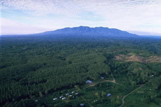 Mount Balbi is seen here from the village of Wakunai, E of the volcano along the NE coast of Bougainville Island. Balbi is the largest volcano on the island and has a NW-SE-trending chain of vents.
Photo by Wally Johnson, 1987 (Australia Bureau of Mineral Resources).
 The 192 km2 Lihir Island, approximately 22 km long in the N-S direction, is shown in this July 2019 Planet Labs satellite image monthly mosaic (N is at the top). The Ladolam gold deposit open pit mine is visible on the E coast within the remains of Luise volcano that has undergone flank collapse, resulting in a 1-km-long debris avalanche deposit offshore. After the collapse event the gold deposit accumulated from hydrothermal fluids.
Satellite image courtesy of Planet Labs Inc., 2019 (https://www.planet.com/).
 Scientists from the Rabaul Volcano Observatory and the U.S. Geological Survey observe an eruption plume from Tavurvur volcano on 4 October 1994, while conducting deformation measurements on Matupit Island. This location was a tilt site where repeated measurements of uplift or subsidence were made during the course of the eruption. The pit at the lower right was excavated to study ashfall deposits from the eruption.
Photo by Elliot Endo, 1994 (U.S. Geological Survey).
 Lava in the center of the crater of Tavurvur volcano on 7 October 1994 as an ash plume rises from a vent to the E. Impact craters from volcanic bombs ejected by the volcano can be seen in the foreground on the flanks of the cone. Explosive eruptions from Tavurvur began on 19 September. Ash plumes initially reached a maximum height of 6 km, although typical heights were 1-2 km. A small lava flow was first seen in the summit crater of Tavurvur on 30 September.
Photo by Andy Lockhart, 1994 (U.S. Geological Survey).
 A large raft of floating brownish pumice from the 1994 eruption of Rabaul volcano obscures the surface of Blanche Bay. The pumice originated from Vulcan volcano (center) during a series of explosive eruptions beginning on 19 September. The larger, light-colored objects in the pumice raft are floating coconuts. This photo was taken on 11 October, three weeks after the start of the eruption, and nine days after activity ceased at Vulcan.
Photo by Andy Lockhart, 1994 (U.S. Geological Survey).
 The youngest-known eruption of Dakataua caldera produced these cones on Mount Makalia, probably during the 1890s. The vent to the right in this image produced a lava flow that is only partly vegetated and descends the E flank of Mount Makalia. The cones are located along a N-S-trending chain of scoria cones and maars across the 12-km-wide caldera lake.
Photo by Russell Blong, 1988 (Macquarie University).
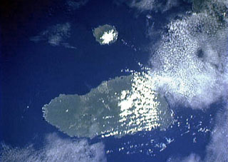 The small circular island at the top-center is Sakar, the NE-most of a chain of volcanic islands off the northern coast of Papua New Guinea. The 8 x 10 km wide island, seen in this Space Shuttle image with north to the upper left, is an incised stratovolcano with a summit crater lake. The 50-km-wide island of Umboi, whose left side is cut by a large caldera breached to the NE, fills the center of the image.
NASA Space Shuttle image STS50-100-D, 1992 (http://eol.jsc.nasa.gov/).
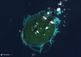
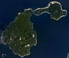 Ambitle Island is on the left and Babase Island is to the upper right in this February 2020 Planet Labs satellite image monthly mosaic (N is at the top; this image is approximately 21 km across). The 900 x 550 m Ambitle crater is near the center of the larger island and formed within a flank collapse scarp. Lava domes produced block-and-ash flow deposits and lava flows are also present.
Satellite image courtesy of Planet Labs Inc., 2020 (https://www.planet.com/).
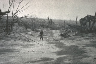
 Waiowa (also known as Goropu) is an isolated tuff cone that was formed during 1943-44 by explosive eruptions through Paleozoic to pre-Cambrian metamorphic rocks. The active vents, seen here on 14 February 1944, were formed in an area without previous volcanic activity. Intermittent minor explosions began on 18 September 1943. Larger explosions occurred on 27 December 1943, 13 February, and 23 July 1944. After the final eruption on 31 August, the volcano was capped by a 500-m-wide crater that now contains a small lake.
Photo courtesy of Jim Luhr (Smithsonian Institution, published in Baker, 1946).
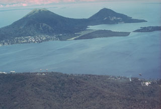 Rabaul caldera and Blanche Bay are seen here from the west. Two pre-caldera cones lie across the bay, Mount Kombiu (known as The Mother) on the left and Mount Turangunan (known as the South Daughter) on the right. Rabaul city lies below Kombiu, and the post-caldera Tavurvur is the partly unvegetated volcano below and to the right of Turangunan. Flat-lying Matupit Island (upper right) has undergone significant uplift during recent periods of caldera unrest.
Photo by Russell Blong, 1980 (Macquarie University).
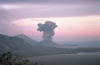 Eruptions from Tavurvur and Vulcan began within about an hour of each other on 19 September 1994. Powerful explosions from Vulcan produced ash plumes estimated to be as high as 21-30 km, pyroclastic flows that extended about 3 km, and the large rafts of floating pumice seen in the foreground of this photo. About 53,000 people were evacuated from Rabaul and surrounding areas, and there were few fatalities. Vulcan stopped erupting on 2 October, but Tavurvur, seen here from the NW in October, continued erupting into 1995.
Photo by Elliot Endo, 1994 (U.S. Geological Survey).
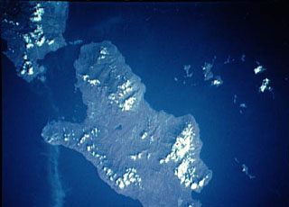
 The roughly 4.5-km-wide Baluan Island of Papua New Guinea is a Pleistocene volcano with several flank vents and a 750-m-wide summit crater visible in this 4 December 2019 Sentinel-2 satellite image (N is at the top).
Satellite image courtesy of Copernicus Sentinel Data, 2019.
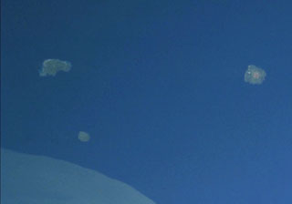 The small island to the upper left is Blup Blup. This 3.5-km-wide forested island contains lava flows with well-defined flow fronts and a weak thermal area is located on the W coast. No historical eruptions have occurred, but the volcano may have been active during the Holocene. It is part of the Schouten Islands, along with Kadovar volcano (the small circular island to the S) and Bam volcano (right).
NASA Space Shuttle image STS106-719-49, 2000 (http://eol.jsc.nasa.gov/).
 The roughly 10 x 12 km Hargy caldera is shown in this 9 January 2018 Sentinel-2 satellite image (N at the top) with Lake Hargy in the SE corner. The Galloseulo cone with its approximately 650-m-wide summit crater is also within the caldera, W of the lake.
Satellite image courtesy of Copernicus Sentinel Data, 2018.
 The circular, 5.5-km-wide island of Baluan (center) in the Admiralty Islands lies SE of Manus Island and across the St. Andrew Strait from Lou and Tuluman islands (out of view to the N). This Pleistocene volcano has a large summit crater and several flank vents. In contrast to its neighboring islands to the N, Baluan has erupted basaltic rather than rhyolitic rocks. The Pam Islands to the NE are visible at the upper right in this NASA Landsat image (N is to the top).
NASA Landsat 7 image (worldwind.arc.nasa.gov)
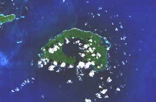
 The center of Garove Island is a lagoon likely formed through edifice collapse, with debris avalanche deposits offshore. Cones have formed across the flanks, with Peter Hafen crater along the NE coast visible in this 4 December 2019 Sentinel-2 satellite image (N is at the top; this image is approximately 15 km across).
Satellite image courtesy of Copernicus Sentinel Data, 2019.
 The most prominent feature of Garove Island, located N of New Britain, is a 5-km-wide caldera that is flooded by the sea through a narrow breach on the S side of the island, forming Johann Albrecht harbor. Satellite cones formed along the NE and SW coasts of the 12-km-wide island. No historical eruptions are known from Garove (also known as Vitu, or Witu), but the preservation of fresh lava flow structures on the NW coast suggests an age as young as a few hundred years. The E tip of Mundua Island is visible at the upper left.
NASA Landsat 7 image (worldwind.arc.nasa.gov)
 The Krummel-Garbuna-Welcker volcanic complex at the S end of the Willaumez Peninsula, across Stetin Bay. The complex consists of three volcanic peaks, Krummel, Garbuna, and Welcker, along a N-S line. The most prominent peaks, Welcker (right) and Krummel (left), form the N and S sides of the complex, respectively. The lower peaks of the centrally located Garbuna contain a large unvegetated area with an extensive thermal field.
Photo by Elliot Endo, 2002 (U.S. Geological Survey).
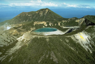
 Billy Mitchell truncated by a 2-km-wide caldera containing a lake. It is seen here from the north, with the eroded, forested Reini volcano on the center horizon and neighboring Bagana volcano at the top right. Billy Mitchell has been the source of some of the largest Holocene eruptions of Papua New Guinea. Two major explosive eruptions, one about 900 years ago and the other about 370 years ago, produced ashfall across most of the N half of Bougainville Island.
Photo by Wally Johnson, 1989 (Australia Bureau of Mineral Resources).
 Conical Bola volcano (also known as Wangore) rises to the NW across Stetin Bay. The symmetrical stratovolcano is located immediately SW of Dakatau caldera and forms the high point of the Willaumez Peninsula in central New Britain. The forested cone has a well-preserved, 400-m-wide crater. No historical eruptions have been documented from Bola, but its morphology suggests very recent activity.
Photo by Elliot Endo, 2002 (U.S. Geological Survey).
 Ambitle (left center) is the larger of two adjacent islands forming the Feni Islands. The 13-km-long island is dominantly Pliocene-to-Pleistocene with a 3-km-wide central caldera. A maar on the E side of post-caldera lava domes formed about 2,300 years ago. Thermal areas are active within the caldera and just off the W coast. Babase Island, immediately to the NE of Ambitle, is a Pleistocene volcano and lava dome connected by a narrow isthmus.
NASA Space Shuttle image STS88-706-56, 1998 (http://eol.jsc.nasa.gov/).
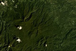 The Takuan Group in southern Bougainville Island, Papua New Guinea, is shown in this Planet Labs satellite image monthly mosaic (N is at the top; this image is approximately 12.5 km across). The group contains three edifices along a NW-SE trend, all of which have probable collapse scarps, and erosion on the flanks. The volcano in the center has a lava dome that has formed within the scarp.
Satellite image courtesy of Planet Labs Inc., 2018 (https://www.planet.com/).
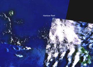 Hankow Reef is partially truncated just below the upper left corner of the cloud-covered portion of this NASA Landsat composite image (with north to the top). The possible existence of a now-submerged volcano named Yomba off the coast of Papua New Guinea is inferred from oral tradition and is considered to likely be at the location of Hankow Reef. The reef lies SE of Bagabag Island (upper left) and NW of Long Island, the larger island at the lower right. Crown Island lies beneath the cloud cover between Long Island and Hankow Reef.
NASA Landsat 7 image (worldwind.arc.nasa.gov)
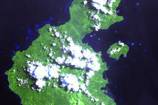 The Garua (Talasea) Harbour volcanic field (upper right center) consists of a group of mostly rhyolitic lava domes and ash cones that ring the harbor on the west and form Garua Island (right center) to the east. Active hot springs ring the shores of Garua Harbour, including a large group of boiling pools, fumaroles, and mudpots located near the Talasea Government Station on the south shore of the bay, directly opposite the western tip of Garua Island.
NASA Landsat image, 2000 (courtesy of Hawaii Synergy Project, Univ. of Hawaii Institute of Geophysics & Planetology).
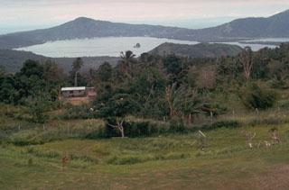 The second of two Holocene caldera-producing eruptions at Rabaul volcano took place about 1,400 years ago. The eruption produced voluminous ashfall and pyroclastic flow deposits, followed by collapse that created the 8 x 14 km caldera, seen here from near its SW rim. The eruption originated from a location near the small, steep-sided island in the center of the bay, Davapia Rocks (also known as The Beehive), an erosional remnant of a post-caldera cone.
Photo by Russell Blong, 1980 (Macquarie University).
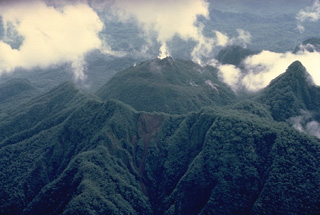 Nearly three decades after its catastrophic eruption in 1951, Mount Lamington is mantled with dense vegetation. This aerial view from the south shows the rounded summit lava dome (center) that was emplaced during 1951-56 in a horseshoe-shaped crater breached to the north. The arcuate ridge in the foreground and the sharp peak at the right mark the rim of 1951 crater.
Copyrighted photo by Katia and Maurice Krafft, 1979.
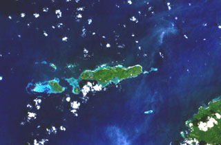 A cluster of basaltic volcanoes forms the Mundua Islands, N of New Britain. The largest volcanic center is formed by the western tip of the 7-km-wide Mundua Island and the arcuate Wingoru Island immediately to the west. The crater is flooded by the sea through narrow channels on the N and S sides. Small cones can be seen on the E side of Mundua. The W tip of Garove Island is visible at the lower right in this NASA Landsat image.
NASA Landsat 7 image (worldwind.arc.nasa.gov)
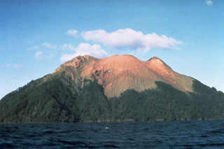 The small 2.4 x 1.6 km island of Bam, seen here from the S, is the summit of a mostly submerged volcano that is one of the more active in Papua New Guinea. A 300-m-wide and 180-m-deep summit crater is source of recent eruptions, which have resulted in the sparsely-vegetated area. A younger cone (center) formed inside a SE-facing landslide scarp. Eruptions recorded since 1872 involved small-to-moderate explosive activity from the summit crater.
Photo by Wally Johnson, 1970 (Australia Bureau of Mineral Resources).
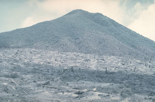 This September 1979 view looks S towards Kanagioi peak across the devastated zone of the 8 March 1979 explosion. Trees in the foreground, on the southern rim of the caldera, were blown down and removed by a lateral explosion from a new vent on the caldera floor 300 m below. An area of standing singed trees extends up the slopes of Kanagioi. A crescent-shaped area extending up to 900 m from the caldera was devastated by the explosion, which killed volcanologists Robin Cooke and Elias Ravian who were monitoring the eruption.
Photo by William Melson, 1979 (Smithsonian Institution)
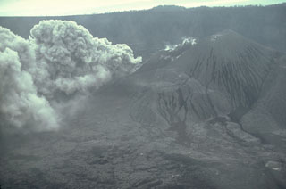 A new vent on the floor of Karkar's inner caldera began erupting on 12 January 1979. On 8 March a major phreatic eruption from the vent produced a directed explosion that devastated an area on the southern caldera rim. The explosion enlarged the January crater to a diameter of 300 m and a depth of 200 m. This 17 April view from the NE shows a low ash plume rising from the new crater.
Photo by William Melson, 1979 (Smithsonian Institution)
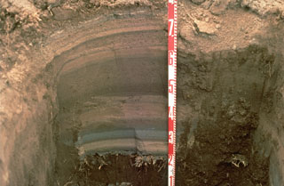 Tephra layers from the 1994 eruption of Rabaul volcano are exposed in this pit dug at the eastern end of Rabaul town in Papua New Guinea. Individual layers are ashfall deposits from discrete explosive eruptions that occurred over three weeks. The light-colored layer near the bottom was produced by an eruption from Vulcan cone at the western end of the caldera. Most other layers originated from periodic explosions at the Tavurvur cone, closer to this site. The numbers on the scale mark 10-cm increments.
Photo by Andy Lockhart, 1994 (U.S. Geological Survey).
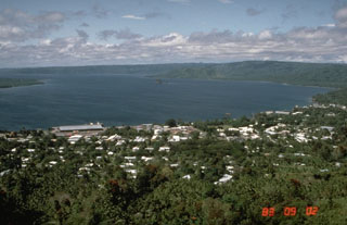 Simpson harbor, seen here from Rabaul Volcano Observatory overlooking the city of Rabaul in 1983, fills the NW part of 8 x 14 km Rabaul caldera. Matupit Island appears at the left margin of the photo, and Vulcan, the site of major eruptions in 1937 and 1994, is the low cone across the harbor at the right-center.
Photo by Norm Banks, 1983 (U.S. Geological Survey).
 The city of Rabaul is seen here in 1969. The low-lying Rabaul caldera forms a sheltered harbor once utilized by New Britain's largest city. A powerful explosive eruption in 1994 forced its evacuation. The 8 x 14 km caldera opens on the W, where its floor is flooded by Blanche Bay. Two major Holocene caldera-forming eruptions took place as recently as 3,500 and 1,400 years ago. Several post-caldera cones, including Tavurvur to the far right, have recorded eruptions.
Photo by Wally Johnson, 1969 (Australia Bureau of Mineral Resources).
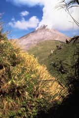 A plume rises above the Bagana summit lava dome on 18 June 1987. To the right of this view an older lava flow from Bagana is visible. The extrusion of viscous andesitic lava flows has occurred throughout much of the 20th century.
Photo by Wally Johnson, 1987 (Australia Bureau of Mineral Resources).
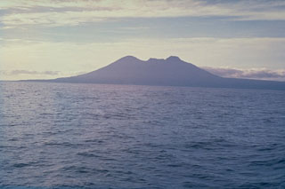 The broad profile of Long Island, seen here from the E, is composed of two steep-sided edifices, Mount Reaumur to the north (center) and Cerisy Peak to the south. Collapse of the volcanic complex during at least three major explosive eruptions about 16,000, 4,000, and 300 years ago produced a large 10 x 12.5 km caldera, whose low rim appears at the right.
Photo by Russel Blong, 1976 (Macquarie University).
 The vegetated Sessagara volcanic group contains several small cones, two with summit craters, seen in this Planet Labs satellite image monthly mosaic (N is at the top; this image is approximately 12 km across). The eroded topographic high to the lower right may also be a cone.
Satellite image courtesy of Planet Labs Inc., 2019 (https://www.planet.com/).
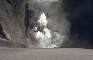 An ash plume from a phreatic explosion rises above a small crater lake at Karkar volcano on 22 April 1979. Following a major explosion from a new vent on the floor of the caldera on 8 March, minor explosions took place until May, after which activity intensified. A lake was briefly seen the day after this photo was taken. The lake disappeared after a strong explosion that night, which deposited ash on the SW caldera floor.
Photo by William Melson, 1979 (Smithsonian Institution)
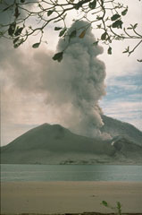 An ash plume rises above Tavurvur volcano on 3 October 1994, two weeks after the onset of a major eruption of Rabaul caldera. Tavurvur, one of two volcanoes that were active on opposite sides of the caldera, is seen here from the west at Kaputin Point on Matupit Island. The brown area in the foreground is a raft of floating pumice from the 19 September-2 October eruption of Vulcan volcano on the W side of the caldera.
Photo by Elliot Endo, 1994 (U.S. Geological Survey).
 Plumes rise from a slow-moving andesite lava flow descending the NW flank of Bagana on 26 April 1988. The flow at that time had been moving for about 3 or 4 years and is typical of the lava extrusion that began in 1972. This volcano was largely constructed by an accumulation of viscous andesite lava flows like this one.
 Photo by Wally Johnson, 1988 (Australia Bureau of Mineral Resources).
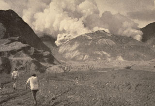 Members of a scientific team approach the crater of Mount Lamington through the avalanche valley on 11 February 1951. Explosions occurred from a vent behind the new lava dome growing in the summit crater produce gas and ash plumes. Growth of the lava dome began soon after the catastrophic 21 January explosive eruption. At the time of this photo, the smooth-surfaced lava dome was uplifting the floor of the new crater. The dome eventually grew to the height of the crater rim.
Photo by Tony Taylor, 1951 (Australia Bureau of Mineral Resources).
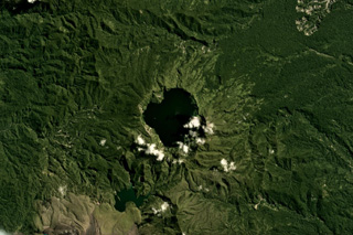 Billy Mitchell has produced some of the largest Holocene eruptions in Papua New Guinea, including the activity that produced the caldera in the center of this May 2018 Planet Labs satellite image monthly mosaic (N is at the top; this image is approximately 13 km across). Large eruptions around 900 and 370 years ago emplaced pyroclastic-flow and tephra deposits that reach 25 km away. Lava flows on the flanks of Bagana are to the lower left.
Satellite image courtesy of Planet Labs Inc., 2018 (https://www.planet.com/).
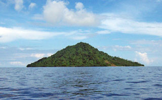 The small forested island of Narage in the Bismarck Sea north of western New Britain is the northernmost of the Witu (or Vitu) Islands. Narage is the summit of a Pleistocene volcano that rises about 300 m above sea level and has strong thermal activity. Boiling springs and a geyser are found along the coast and a 45-m-high geyser was observed at a sandbank 8 km offshore in 1863.
Photo by Jean Guillou, courtesy of René Guenerie.
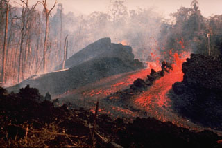 An E-flank fissure located 5 km from the summit produced an incandescent lava flow during 10-14 May 1978 that traveled 6 km to the Pandi River. Explosive activity took place from the summit crater of Ulawun over 7-13 May, accompanied by pyroclastic flows from a fissure high on the SE flank on 9 May. At least a dozen vents were active during this eruption.
 Photo by K. Spellmeyer, 1978 (courtesy of Wally Johnson, Australia Bureau of Mineral Resources).
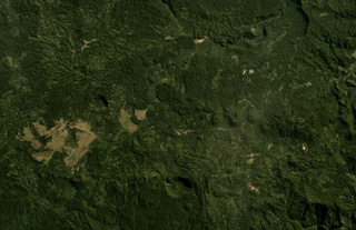 Thirty small volcanic centers have been identified in the Managlase Plateau in SE Papua New Guinea. Some of these are shown in this July 2019 Planet Labs satellite image monthly mosaic (N is at the top; this image is approximately 13 km across). Several vegetated craters, lava domes, and cones are visible across this image, and lava flows have also been reported.
Satellite image courtesy of Planet Labs Inc., 2019 (https://www.planet.com/).
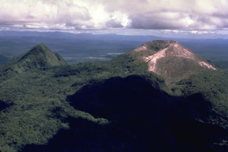 Pago (right), seen here from the N, is a young cone that was constructed within the 5.5 x 7.5 km Witori caldera. Caldera formation occurred about 3,300 years ago and was accompanied by voluminous pyroclastic flows. Pago, which may have formed less than 350 years ago, has grown to a height above the caldera rim. The vegetated lava flow that descends to the left between Pago and the peak to the left was emplaced during a 1911-18 eruption. The 5-km-long lava flow banked against the eastern caldera rim.
Photo by Wally Johnson, 1968 (Australia Bureau of Mineral Resources).
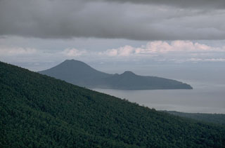 Lolobau is located on the western rim of a 6-km-wide caldera, which formed about 12,000 years ago on the 8 x 13 km Lolobau Island. It is seen here from the south beyond the lower flanks of Ulawun. The smaller peak to the right is located along the eastern caldera rim.
Photo by Robert Citron, 1970 (Smithsonian Institution; courtesy of William Melson)
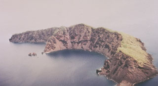 This arcuate, 1.9-km-long, 200-m-wide island is what remains of Ritter Island after its collapse in 1888. Prior to 1888 this was a steep-sided nearly circular island about 780 m high. Large-scale slope failure removed the summit of the conical volcano, leaving an arcuate 140-m-high west-facing scarp, seen here from the SW. Two minor post-collapse explosive eruptions occurred offshore during 1972 and 1974.
Photo by Wally Johnson, 1974 (Australia Bureau of Mineral Resources).
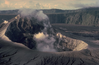 Steam rises from the summit crater of Bagiai cone in the inner caldera of Karkar volcano in September 1979, shortly after an eruption that ended in August. Fresh pyroclastic-fall deposits that mantle the slopes of the cone originated from a new vent on the caldera floor at the SE base of Bagiai. This view from the south caldera rim looks across Bagiai cone to the wall of the inner caldera. The outer caldera wall forms the horizon.
Copyrighted photo by Katia and Maurice Krafft, 1979.
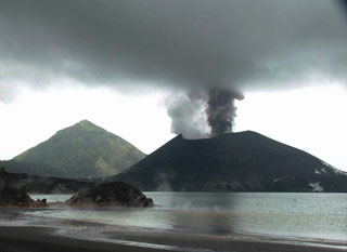 Tavurvur cone at Rabaul is seen in eruption in this 25 May 2005 view looking from the NW across Matupit Harbor. Two plumes, one white and the other dark gray, are originating from separate vents. Intermittent small-to-moderate explosive eruptions took place throughout much of the year. The conical peak in the background is Turanguna.
Photo by Roy Price, 2005 (University of South Florida).
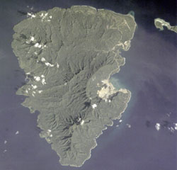 The 20-km-long Lihir Island is a complex of several overlapping Pliocene-to-Holocene volcanoes N of Latangai Island, the youngest of which is Luise volcano. Luise Harbor (right center) lies within a 5.5-km-wide caldera that is breached on the NE side. Thermal activity includes boiling hot springs, mud pools, and sulfur-encrusted low-temperature fumaroles.
NASA Space Shuttle image STS001-5933, 2001 (http://eol.jsc.nasa.gov/).
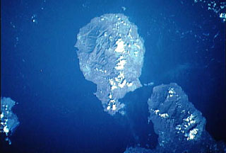 Goodenough (center) is the roughly circular volcanic island that is the westernmost of the D'Entrecasteaux Islands in this NASA satellite image with north to the upper right. Several Holocene eruptive centers that may be only a few hundred years old are located around the margins of fault-bounded metamorphic rocks that form the central part of Goodenough Island. The youngest volcanic features, which include the Walilagi Cones, are located at the SE end of the island on the Bwaido Peninsula (lower center).
NASA Space Shuttle image STS44-83-79, 1991 (http://eol.jsc.nasa.gov/).
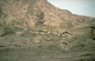 Thick deposits of ash from the 1994 eruption of Rabaul volcano covered the city of Rabaul, partially burying cars and houses. The eruption forced the abandonment of the town, once the largest on the island of New Britain, and a total of 53,000 people were evacuated from the city and surrounding areas. An estimated 30,000 people evacuated the day the eruption began, and the remainder left by land and by sea the following day.
Photo by Andy Lockhart, 1994 (U.S. Geological Survey).
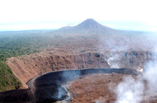 Lolo rises to the N beyond lava flows producing gas plumes during the 2002 eruption of Pago. Lolo is located N of Pago volcano along the N coast of New Britain, near Cape Hoskins. It is of late Pleistocene or Holocene age and overlaps the older Kapberg volcano on its W side. Lola contains a 250-m-wide and 60-m-deep crater.
 Photo by Elliot Endo, 2002 (U.S. Geological Survey).
 The largest historical Rabaul eruption took place from 29 May to 2 June 1937 from two vents on opposite sides of the caldera, Vulcan and Tavurvur. Present-day Vulcan, seen here from the NE, was built up from sea level to a height of 243 m during four days of powerful explosive eruptions that ended the evening of 2 June. About 500 people were killed by pyroclastic flows and heavy ashfall. Rabaul city was buried by ash and pumice, and a tsunami swept ships onto the shore. Tavurvur was active for less than one day.
Photo by Russell Blong, 1980 (Macquarie University).
 The Sulu Range in New Britain, Papua New Guinea spans this 25 July 2019 Sentinel-2 satellite image (N is at the top), with Mount Malopu in the center to the S, Mount Ululu and Ubia to the N, Mount Ruckenberg to the NE, and Mount Talutu dome to the SE. Kaiamu maar forms the peninsula extending about 1 km into Bangula Bay to the NW.
Satellite image courtesy of Copernicus Sentinel Data, 2019.
 The Mundua islands are an E-W trending group of volcanic edifices north of New Britain, Papua New Guinea. The island group is seen here in a 4 December 2019 Sentinel-2 satellite image (N at the top) with a lateral distance of approximately 15 km. The largest island to the E is Ningau, with Goru crater on the far left side. Three smaller island-forming cones can be seen to the W of Ningau, with Silenge, then Vambu from E to W, and Undaga N of Vambu.
Satellite image courtesy of Copernicus Sentinel Data, 2019.
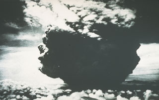 This photograph of the catastrophic eruption of 21 January 1951 was taken by the pilot flying from Port Moresby to Rabaul. From about 40 km NW, the pilot observed this ash plume rising to a height of about 13 km within two minutes. Shortly afterwards, the cloud expanded horizontally away from the volcano as devastating pyroclastic flows and surges swept radially up to 12 km from the crater.
Photo by Capt. Jacobson, 1951 (published in Taylor, 1958).
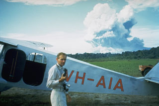 Australian volcanologist Tony Taylor in front of Mount Lamington, which is erupting in the distance on 5 February 1951. Taylor investigated the activity at Lamington through the course of the eruption.
 Photo courtesy of Wally Johnson, 1951 (Australia Bureau of Mineral Resources).
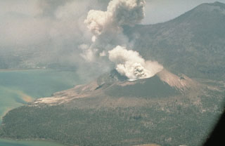 Tavurvur ejects an ash plume in October 1994, following an eruption that began on 19 September. It is seen here from a helicopter with Kombiu volcano (upper right) to the N. Intermittent eruptive activity continued at Tavurvur for several years after the 1994 eruption.
Photo by Elliot Endo, 1994 (U.S. Geological Survey).
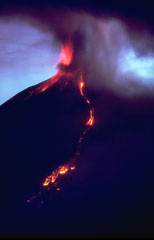 Incandescent lava flows descend the NW flank of Ulawun at dusk on 21 November 1985 as Strombolian activity occurs at the summit. Strombolian explosions began with the onset of the eruption on 17 November. Lava flows began descending the N slope the next day and eventually reached 5.5 km from the summit. On 20 November an ash plume reached an altitude of 7-8 km. The eruption ended the day after this photo was taken.
Photo by Wally Johnson, 1985 (Australia Bureau of Mineral Resources).
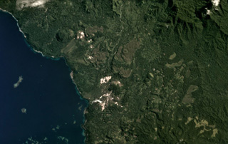 The Iamalele volcanic center on Fergusson Island is an active geothermal area (the white zones) seen in this May 2020 Planet Labs satellite image monthly mosaic (N is at the top; image is approximately 14 km across). The field contains lava domes and an ignimbrite deposit possibly related to caldera collapse.
Satellite image courtesy of Planet Labs Inc., 2020 (https://www.planet.com/).
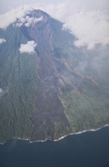 The eruption from Manam that began in 1974 included peaks of activity that produced pyroclastic flows during 1982, 1984, and 1992-94. This December 1992 photo shows a new lava field that was emplaced down the NE valley from August to November 1992. Lava flows from the 1992 eruptions reached the sea on the NE coast and destroyed a village.
Photo by Wally Johnson, 1992 (Australia Bureau of Mineral Resources).
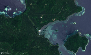 The Garua Harbour volcanic field has produced features throughout much of the area shown in this 25 November 2019 Sentinel-2 satellite image (with N to the top), including the approximately 3.5-km-wide Garua Island in the lower right corner. The field includes lava domes and cones, and has geothermal features including fumaroles and geysers.
Satellite image courtesy of Copernicus Sentinel Data, 2019.
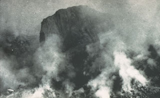 On 19 August 1951 this large lava spine towered about 130 m above the surface of the growing lava dome. Growth of the spine had ceased at about this time. Extrusion and destruction of lava spines occurred frequently during the five-year long period of lava dome growth.
Photo by Tony Taylor, 1951 (Australia Bureau of Mineral Resources).
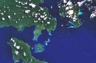 The Dawson Straits, seen in this NASA Landsat image, is located between eastern Fergusson Island (upper left) and northwestern Normanby Island (lower left) in the D'Entrecasteaux island group. The area contains a volcanic field with several young volcanic centers that erupted rhyolitic obsidian flows. Mount Oiau is located on the narrow peninsula (left center) forming the southernmost point on Fergusson Island. A large crater is visible on Dobu Island, southeast of Oiau. Young volcanic rocks are also found on Sanaroa Island (upper right).
NASA Landsat 7 image (worldwind.arc.nasa.gov)
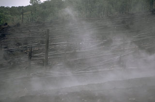 Steam rises from a pyroclastic flow deposit on the NW flank of Ulawun in February 1970. Rainforest trees were blown down facing away from the volcano by a high-velocity pyroclastic surge at the margins of the 22 January pyroclastic flow, which traveled 5 km from the summit. Pyroclastic flow velocities on the upper part of the volcano were estimated to exceed 100 km/hour.
Photo by Robert Citron, 1970 (Smithsonian Institution; courtesy of William Melson)
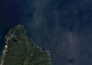 The 9-10 km wide Tavui Caldera off the Gazelle Peninsula in New Britain is along the NE coastline and up to 1.1 km below the ocean surface within the area shown in this November 2019 Planet Labs satellite image monthly mosaic (N is at the top; this image is approximately 14 km across). The caldera contains two cones, one 4.5 km wide in the northern area and the other 1.5 km wide in the northeastern area.
Satellite image courtesy of Planet Labs Inc., 2019 (https://www.planet.com/).
 Two nested calderas are visible in this aerial view from the E of the Karkar summit, taken before the 1974 eruption. The 5.5-km-wide outer caldera formed during one or more eruptions, the last of which occurred 9,000 years ago, and the rim forms the horizon. The 3.2-km-wide inner caldera was formed sometime between 1,500 and 800 years ago and its floor is covered by young lava flows. Bagiai cone (right center) has been the source of most eruptions dating back to 1643.
Photo by Wally Johnson, 1974 (Australia Bureau of Mineral Resources).
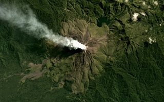 The flanks of Bagana are composed of radial lava flows that erupted from a central summit crater where a gas plume is emitting and dispersing NW, visible in this June 2019 Planet Labs satellite image monthly mosaic (N is at the top; this image is approximately 12 km across). At 2.5 km NW from the crater is a lava dome, and to the NE is the eroded Reini cone.
Satellite image courtesy of Planet Labs Inc., 2018 (https://www.planet.com/).
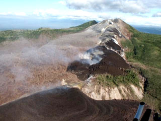 Recently-emplaced lava flows are seen along a SSE line of vents leading towards the summit of Pago in this 16 September 2002 view. The Pago cone that was constructed within the 5.5 x 7.5 km Witori caldera, which formed around 3,300 years ago. Since its formation a few hundred years ago the cone has grown to a height above the caldera rim. A series of ten lava flows, one of which underlies the area of scorched vegetation left of the 2002 lava flows, cover much of the caldera floor.
Photo courtesy of Elliot Endo, 2002 (U. S. Geological Survey Volcanic Disaster Assistance Program).
 Hankow Reef is thought to be the remnant of an eroded volcanic island called Yomba that was described through oral tradition. The reef is visible in this 15 August 2019 Sentinel-2 satellite image (N is at the top) between Bagabag and Crown islands, N of the main island of Papua New Guinea.
Satellite image courtesy of Copernicus Sentinel Data, 2019.
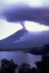 An ash plume erupts from the summit crater of Ulawun volcano on 21 November 1985. Smoke from burning vegetation rises from the front of an incandescent lava flow that is descending the NW flank. Strombolian eruptions had begun four days earlier and lava emission began the following day. The lava flow front bifurcated on the lower flanks of the volcano and the eastern lobe traveled slightly farther, eventually reaching 5.5 km from the summit.
Photo by Wally Johnson, 1985 (Australia Bureau of Mineral Resources).
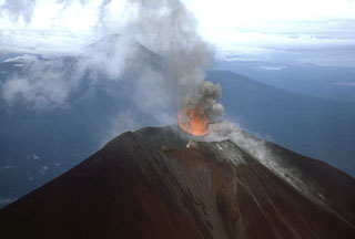 Photograph of Ulawun taken from a helicopter on 25 November 1985. This view from the NE shows the ejection of lava into the air above the vent during Strombolian activity. The other large stratovolcano in the background is Bamus.
 Photo by James Mori, Disaster Prevention Research Institute, Kyoto University.
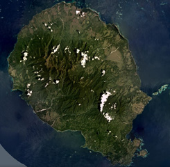 Goodenough Island is the westernmost of the D'Entrecasteaux Islands, Papua New Guinea, shown in this December 2019 Planet Labs satellite image monthly mosaic (N is at the top; this image is approximately 37 km across). The island has several cones around the outer perimeter of the island, surrounding the metamorphic rocks that form the center. The youngest features, such as the Wailagi Cones, are located on the Bwaido Peninsula to the SE.
Satellite image courtesy of Planet Labs Inc., 2019 (https://www.planet.com/).
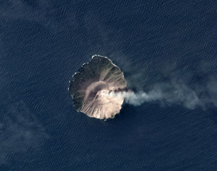 A plume at Kadovar is dispersing to the E in this November 2019 Planet Labs satellite image monthly mosaic (N is at the top). The flanks of the roughly 1.4 x 1.6 km island have been stripped of vegetation due to lava dome formation and collapse at the summit, with recent eruptive activity producing ash plumes and pyroclastic flows. Activity has also recently occurred at the base of the SE flank.
Satellite image courtesy of Planet Labs Inc., 2019 (https://www.planet.com/).
 Mount Victory in Cape Nelson, Papua New Guinea, is shown in this July 2018 Planet Labs satellite image monthly mosaic (N is at the top; this image is approximately 20 km across). The vegetated flanks are eroded and four scoria cones are on the lower SW flank with several craters visible. The summit contains an irregular crater and there are two more cones on the NE flank.
Satellite image courtesy of Planet Labs Inc., 2018 (https://www.planet.com/).
 The St. Andrew Strait volcano is located in the Admiralty Islands north of Papua New Guinea. The volcanic complex consists of a series of overlapping Quaternary cones formed by rhyolitic lava flows and pyroclastic deposits on Lou and Tuluman Islands. Volcanism is aligned along a curved arc, extending through the 12-km-long Lou Island. Tuluman Island, seen here from the SW with Lou Island 1.5 km away at the upper left, was formed during a 1953-57 eruption.
Photo by Wally Johnson, 1964 (Australia Bureau of Mineral Resources).
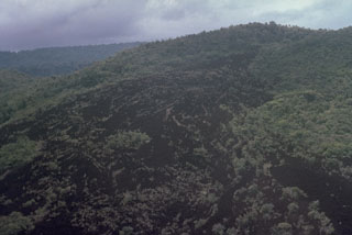 This sparsely-vegetated lava flow appears to be the youngest within Dakataua caldera. It may have been emplaced at the time of the latest known eruption, which took place during the 1890s from the post-caldera cone, Mount Makalia. This is one of several young volcanic features occupying a 7-km-long peninsula.
Photo by Russell Blong, 1988 (Macquarie University).
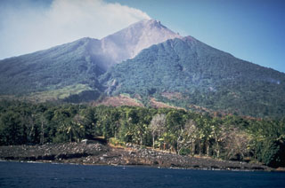 The SW avalanche valley, the smallest of four large radial valleys that extend from the summit of Manam to its lower flanks, is seen here in August 1972. During larger eruptions, pyroclastic flows and lava flows descend all four valleys and sometimes reach the coast. The unvegetated summit is emitting a plume.
Photo by Wally Johnson, 1972 (Australia Bureau of Mineral Resources).
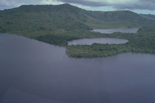 Shown here is the 10.5 x 13.5 km Dakataua caldera at the N tip of the Willaumez Peninsula. Caldera-formatting activity occurred as recently as about 1,150 years ago. A 12-km-wide freshwater lake (foreground), whose surface is only about 50 m above sea level, occupies the caldera. This view from the W shows two maars (right center) and Mount Makalia (top left), which are located along a N-S-trending peninsula.
Photo by Russell Blong, 1988 (Macquarie University).
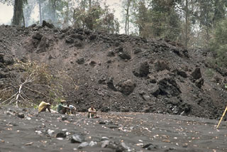 The toe of a blocky lava flow above members of a volcanological field team at Ulawun volcano in February 1970. The lava flow traveled 5 km from the summit, covering a broad area on the upper SW flank before being restricted to a narrow valley on the lower W flank. At its distal end, the flow front was 50 m wide and 8 m high and advanced slowly at a rate of 10 m/hour.
Photo by Robert Citron, 1970 (Smithsonian Institution; courtesy of William Melson)
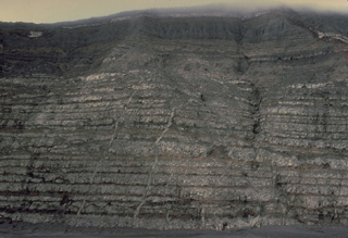 A strong explosive eruption at Karkar volcano in Papua New Guinea in 1979 stripped the southern caldera wall of vegetation, exposing a cross-section of the interior of the stratovolcano. The 300-m-high caldera wall shows thin layers of light-colored lava flows separated by intervening pyroclastic layers, reflecting the repetitive effusive and explosive eruptions that built the volcano. Narrow vertical dikes, the feeder conduits for lava flows, are visible at several locations in the caldera wall.
Copyrighted photo by Katia and Maurice Krafft, 1979.
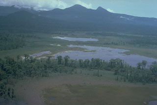 Pago, the flat-topped peak on the center horizon, is a young post-caldera edifice that may have been constructed less than 350 years ago within the 5.5 x 7.5 km Witori caldera. Extensive pyroclastic flows accompanied caldera formation about 3,300 years ago. The low-angled outer slopes of Witori, seen here from the S, consist primarily of pyroclastic flow and airfall deposits produced during a series of five major explosive eruptions from about 5,600 to 1,200 years ago.
Photo by Russell Blong (Macquarie University).
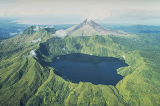 The caldera lake of Billy Mitchell in front of the unvegetated Bagana volcano. The Solomon Sea can be seen in the distance to the SW. Two major explosive eruptions from Billy Mitchell, one about 900 and the other about 370 years ago, produced ashfall that covered most of the N half of Bougainville Island and pyroclastic flow and surge deposits that extend 25 km to the E coast. The younger eruption may have been responsible for formation of the summit caldera.
Photo by Wally Johnson, 1988 (Australia Bureau of Mineral Resources).
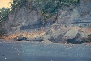 An outcrop on the W coast of Long Island reveals deposits from the last caldera-forming eruption. This catastrophic eruption in the mid-17th century deposited ash across the New Guinea highlands and prompted legends of a "Time of Darkness." This outcrop shows pyroclastic surge and Plinian airfall deposits of the Matapun formation, which is exposed at the top of the section beginning about 4 m above the geologists.
Photo by Russell Blong, 1975 (Macquarie University).
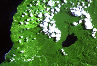 Lake Hargy (lower right) lies in the SE corner of the 10 x 12 km wide Hargy caldera. The Lobu River drains the lake through a notch in the northern caldera rim. The post-caldera cone of Galloseulo lies beneath the large cloud bank in the center of the image, about halfway from the lake to the Bismarck Sea. The Toiru River cuts across the bottom of the image. Small eruptions have taken place at Galloseulo over the past 7,000 years, the last occurring about 1,000 years ago.
NASA Landsat image, 2000 (courtesy of Hawaii Synergy Project, Univ. of Hawaii Institute of Geophysics & Planetology).
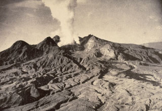 The first historical eruption of Lamington was in 1951, prior to which it was not known to be a volcano by those living on its flanks. Following continuous light ash emission beginning on 17 January the paroxysmal eruption on 21 January produced pyroclastic flows and surges that swept all sides of the volcano to a maximum distance of 12 km to the north, killing nearly 3,000 people. This 5 February photo shows the devastated northern flanks and a plume rising from a growing lava dome in the new crater. Slow dome growth ended in 1956.
Photo by Tony Taylor, 1951 (Australia Bureau of Mineral Resources).
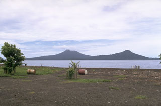 Lolobau volcano (left) is located on the western rim of a caldera that formed about 12,000 years ago on Lolobau Island. It is seen here from the south across Expectation Strait along the NE coast of New Britain. The peak at the right is on the eastern rim of the 6-km-wide caldera. Several vents within the caldera along an E-W-trending line on the E flank have had recorded activity.
Photo by Robert Citron, 1970 (Smithsonian Institution; courtesy of William Melson)
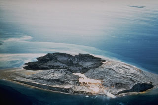 Intermittent submarine explosive and effusive eruptions from multiple vents during June 1953 to January 1957 created new islands that coalesced to form Tuluman Island. Activity was most vigorous during February-March 1955, and near the end of the eruption in January 1957 when subaerial effusive activity dominated. This March 1960 view from the SW shows dark rhyolitic lava flows at the far end of the island and lighter deposits from eroded tuff cones.
Photo courtesy of Wally Johnson, 1960 (Australia Bureau of Mineral Resources).
 The symmetrical Ulawun is one of Papua New Guinea's most frequently active volcanoes. Ulawun and Bamus volcano (upper left) are the two highest volcanoes of the Bismarck Archipelago, and are known as the Father and South Son volcanoes, respectively. The upper 1,000 m of Ulawun is unvegetated. Historical eruptions date back to the beginning of the 18th century.
Photo by Wally Johnson (Australia Bureau of Mineral Resources).
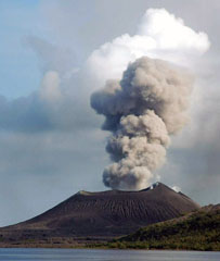 An ash plume rises above Tavurvur volcano at the eastern end of the island of New Britain in Papua New Guinea on 5 June 2005, seen from the SE. Explosive activity had resumed at Tavurvur on 25 January 2005 and continued intermittently until November of that year, occasionally depositing ash on the town of Rabaul. Incandescent ejecta was periodically observed at night time.
Photo by Roy Price, 2005 (University of South Florida).
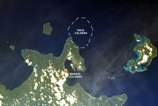 The mostly submarine Tavui caldera at the NE end of New Britain lies off the tip of the Gazelle Peninsula. The SW wall of the roughly 10 x 12 km wide caldera, its margins crudely shown on this image, cuts the NE tip of the peninsula. Tavui caldera, much less known than Rabaul caldera to the S, was first discovered during a bathymetric cruise in 1985. Light ash-covered areas from the 1994 Rabaul eruption can be seen at the western and NE margins of Rabaul caldera in this 1999 NASA Space Shuttle image.
NASA Space Shuttle image STS103-733-52, 1999 (http://eol.jsc.nasa.gov/).
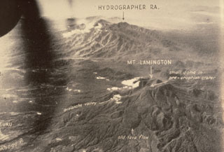 The Hydrographers Range, seen here from the W, is a forested, deeply dissected volcanic massif extending from the E margin of Mount Lamington (lower right) to the northern coast of Papua New Guinea. Most activity took place during the Pleistocene, but well-preserved scoria cones and craters suggest that some Holocene activity occurred. This 1947 photo was taken prior to Lamington's catastrophic eruption in 1951.
Photo by Royal Australian Air Force, 1947 (published in Taylor, 1958).
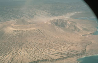 Vulcan, seen here from the SE, was the source of the largest eruptions at Rabaul in 1994. Vulcan began erupting on 19 September from a N-flank vent. Activity intensified rapidly, producing a large eruption column that reached an altitude of 20 km. Pyroclastic flows traveled radially down the flanks of the cone as far as 3 km and resulted in darkness in Rabaul city. The eruption originated from a N-S-trending fissure, seen here at the right. The scarp in the foreground was produced by a 5-m uplift the day before the eruption.
Photo by Elliot Endo, 1994 (U.S. Geological Survey).
 The 10-km-wide island of Manam is one of Papua New Guinea's most active volcanoes. Four large radial valleys extend from the unvegetated summit to its lower flanks and two summit craters are present. Most eruptions during the past century have originated from the southern crater, concentrating eruptive products into the SE avalanche valley, seen here from off the east coast of the island. Frequent eruptions have been recorded since 1616.
Photo by Wally Johnson (Australia Bureau of Mineral Resources).
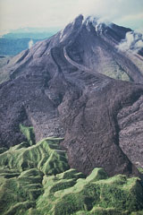 Bagana volcano, on Papua New Guinea's Bougainville Island, is characterized by the extrusion of thick, viscous andesitic lava flows. This photo shows a large lava flow with prominent lateral levees descending from the summit and ponding against forested hills at the base of the volcano. Bagana is constructed almost entirely of overlapping lava-flow lobes. Slow lava extrusion, occasionally accompanied by explosive activity, has been common since the mid-1800s.
Photo by Wally Johnson, 1988 (Australia Bureau of Mineral Resources).
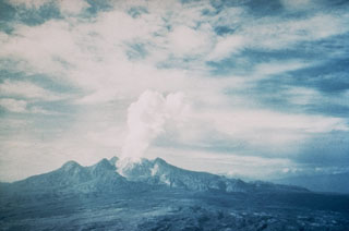 Mount Lamington, seen here from the north in late 1951, has a 1.3-km-wide summit crater containing a lava dome. Prior to its disastrous eruption in 1951, the forested peak had not been recognized as a volcano. The 1951 eruption produced pyroclastic flows and surges that devastated all sides of the volcano, killing nearly 3,000 people. The eruption concluded with growth of a 560-m-high lava dome in the summit crater.
Photo by Tony Taylor, 1951 (courtesy of Wally Johnson, Australia Bureau of Mineral Resources).
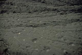 A strong directed explosion on March 8, 1979 from a vent on the floor of Karkar's inner caldera ejected large blocks that produced these impact craters on the southern rim of the caldera. The craters, photographed here in September 1979, measured up to about 7-m wide and over 2-m deep. The thin tephra deposit ranged from about 10-40 cm in thickness. The directed explosions, estimated to be at an angle of 30-60 degrees above the horizontal, destroyed a formerly dense rainforest over a crescent-shaped area extending up to 900 m from the caldera rim.
 Copyrighted photo by Katia and Maurice Krafft, 1979.
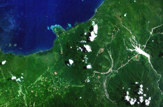 Forested volcanoes of the Sulu Range occupy the center of this NASA Landsat image (N is to the top) of west-central New Britain. This group of partially overlapping small volcanoes and lava domes off Bangula Bay reaches heights of about 600 m. Mount Karai, also known as Mount Ruckenberg, lies on the NE side of the geochemically diverse, basaltic-to-rhyolitic complex. Kaiamu maar forms the peninsula extending about 1 km into Bangula Bay at the NW side of the Sulu Range.
NASA Landsat7 image (worldwind.arc.nasa.gov)
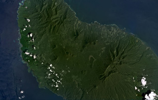 Umboi Island is around 50 km long in the NW-SE direction and has volcanic features visible in the NW, in the center of this January 2021 Planet Labs satellite image monthly mosaic (N is at the top; this image is approximately 40 km across). The larger crater near the top of the center of the island (N of the lake) is Bono of Soal volcano, and W is the eroded Barik cone. S of that is a NNW-SEE trend of craters named Pung, Talo, Apalong, and Tanglup from W to E.
Satellite image courtesy of Planet Labs Inc., 2021 (https://www.planet.com/).
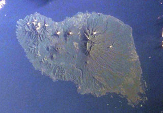 The 50-km-long island of Umboi, the largest of the volcanic islands off the north coast of New Guinea, is seen in this Space Shuttle image (N is to the top-right). A large 13 x 17 km caldera is visible in the northern half of the island and is breached to the NE (top center). Three post-caldera cones with summit crater lakes (left center) are visible on the smooth-surfaced caldera floor. The large eroded massif (right center) is an older volcanic complex, as is the dissected northern tip of the island (upper left).
NASA Space Shuttle image STS50-99-748-47, 2000 (http://eol.jsc.nasa.gov/).
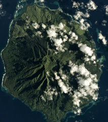 The 7.5 x 9 km Sakar is the NE-most of a chain of volcanic islands off the northern coast of Papua New Guinea, seen in this February 2017 Planet Labs satellite image monthly mosaic (N is at the top). The flanks are deeply eroded, but the summit crater contains a lake in the SE section and there is a cone on the S flank.
Satellite image courtesy of Planet Labs Inc., 2017 (https://www.planet.com/).
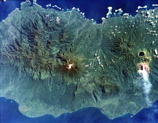 Tore volcano is in the Emperor Range on NW Bougainville Island. The Tore massif lies to the left of Balbi volcano, which is the light-colored area at the center of the image. Two Pleistocene ignimbrites from Tore formed a broad fan that extends the coastline to the W (lower left). The dark-colored caldera lake of Billy Mitchell volcano is at the right, above a plume originating from Bagana volcano. N is to the upper left of this NASA image.
NASA International Space Station image ISS001-358-32, 2001 (http://eol.jsc.nasa.gov/).
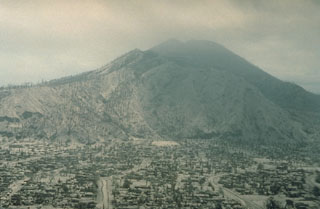 The city of Rabaul lies buried beneath a thick blanket of ash from the 1994 eruption. Mount Kombiu rises to the west above the deserted streets of the town. Ashfall from Tavurvur volcano during the first few days of the eruption caused widespread damage. Virtually every building in the south part of the town collapsed. Heavy rainfall at the time of the eruption produced lahars that caused additional damage.
Photo by Andy Lockhart, 1994 (U.S. Geological Survey).
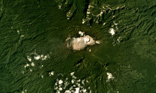 A series of craters have formed along a NW-SE-trending ridge on Balbi, seen in this January 2018 Planet Labs satellite image monthly mosaic (N is at the top; this image is approximately 15 km across). Part of the summit area is vegetation-free and geothermal activity continues.
Satellite image courtesy of Planet Labs Inc., 2018 (https://www.planet.com/).
This is a compilation of Papua New Guinea volcano information sources, such as official monitoring or other government agencies.
| Additional Information Sources | |
|---|---|
| United Nations Development Programme- Papua New Guinea | |
| Volcanic Ash Advisory Center | |
|---|---|
| Darwin Volcanic Ash Advisory Centre (VAAC) | |
| - Darwin VAAC Archive | |